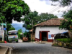
Perquín | |
|---|---|
Municipality | |
 | |
| Coordinates: 13°57′N 88°10′W / 13.950°N 88.167°W | |
| Country | |
| Department | Morazán Department |
| Government | |
| • Mayor | Imelda Maribel Sorto ( ARENA) |
| Elevation | 3,665 ft (1,117 m) |
Perquín is a municipality in the Morazán department of El Salvador.
It is home to the Museum of the Revolution, which contains artifacts and exhibits related to the Salvadoran Civil War. Exhibits include a recreation of Radio Venceremos, a civil war-era opposition radio station that was broadcast throughout the country and re-broadcast via short wave radio throughout the world during the 1980s. Today Radio Venceremos is a commercial radio station called la RV.
Perquin is surrounded by coffee plantations and green pinegroves and hosts an annual festival that takes place during the first week of August.[ citation needed]
| Climate data for Perquín (1991–2020) | |||||||||||||
|---|---|---|---|---|---|---|---|---|---|---|---|---|---|
| Month | Jan | Feb | Mar | Apr | May | Jun | Jul | Aug | Sep | Oct | Nov | Dec | Year |
| Mean daily maximum °C (°F) | 26.6 (79.9) |
27.9 (82.2) |
28.9 (84.0) |
28.9 (84.0) |
27.1 (80.8) |
26.3 (79.3) |
26.9 (80.4) |
26.7 (80.1) |
25.8 (78.4) |
25.4 (77.7) |
25.8 (78.4) |
26.2 (79.2) |
26.9 (80.4) |
| Daily mean °C (°F) | 20.1 (68.2) |
20.8 (69.4) |
21.6 (70.9) |
22.3 (72.1) |
21.7 (71.1) |
21.2 (70.2) |
21.6 (70.9) |
21.2 (70.2) |
20.5 (68.9) |
20.3 (68.5) |
20.2 (68.4) |
20.1 (68.2) |
21.0 (69.8) |
| Mean daily minimum °C (°F) | 15.9 (60.6) |
16.2 (61.2) |
16.9 (62.4) |
18.0 (64.4) |
18.1 (64.6) |
18.0 (64.4) |
17.9 (64.2) |
17.8 (64.0) |
17.6 (63.7) |
17.5 (63.5) |
16.8 (62.2) |
16.3 (61.3) |
17.3 (63.1) |
| Average precipitation mm (inches) | 5.2 (0.20) |
6.0 (0.24) |
27.0 (1.06) |
89.1 (3.51) |
365.7 (14.40) |
442.4 (17.42) |
310.5 (12.22) |
404.1 (15.91) |
559.3 (22.02) |
437.6 (17.23) |
99.6 (3.92) |
11.8 (0.46) |
2,758.1 (108.59) |
| Average relative humidity (%) | 67 | 65 | 65 | 71 | 81 | 85 | 77 | 82 | 89 | 87 | 77 | 71 | 76.3 |
| Source: Ministerio de Medio Ambiente y Recursos Naturales [1] | |||||||||||||
- Prodetur – ecotourism organization active in Perquin
- ^ "Normales Climatológicas 1991-2020" (in Spanish). Ministerio de Medio Ambiente y Recursos Naturales. Archived from the original on May 13, 2024. Retrieved May 13, 2024.
![]() Media related to
Perquín at Wikimedia Commons
Media related to
Perquín at Wikimedia Commons
Perquín | |
|---|---|
Municipality | |
 | |
| Coordinates: 13°57′N 88°10′W / 13.950°N 88.167°W | |
| Country | |
| Department | Morazán Department |
| Government | |
| • Mayor | Imelda Maribel Sorto ( ARENA) |
| Elevation | 3,665 ft (1,117 m) |
Perquín is a municipality in the Morazán department of El Salvador.
It is home to the Museum of the Revolution, which contains artifacts and exhibits related to the Salvadoran Civil War. Exhibits include a recreation of Radio Venceremos, a civil war-era opposition radio station that was broadcast throughout the country and re-broadcast via short wave radio throughout the world during the 1980s. Today Radio Venceremos is a commercial radio station called la RV.
Perquin is surrounded by coffee plantations and green pinegroves and hosts an annual festival that takes place during the first week of August.[ citation needed]
| Climate data for Perquín (1991–2020) | |||||||||||||
|---|---|---|---|---|---|---|---|---|---|---|---|---|---|
| Month | Jan | Feb | Mar | Apr | May | Jun | Jul | Aug | Sep | Oct | Nov | Dec | Year |
| Mean daily maximum °C (°F) | 26.6 (79.9) |
27.9 (82.2) |
28.9 (84.0) |
28.9 (84.0) |
27.1 (80.8) |
26.3 (79.3) |
26.9 (80.4) |
26.7 (80.1) |
25.8 (78.4) |
25.4 (77.7) |
25.8 (78.4) |
26.2 (79.2) |
26.9 (80.4) |
| Daily mean °C (°F) | 20.1 (68.2) |
20.8 (69.4) |
21.6 (70.9) |
22.3 (72.1) |
21.7 (71.1) |
21.2 (70.2) |
21.6 (70.9) |
21.2 (70.2) |
20.5 (68.9) |
20.3 (68.5) |
20.2 (68.4) |
20.1 (68.2) |
21.0 (69.8) |
| Mean daily minimum °C (°F) | 15.9 (60.6) |
16.2 (61.2) |
16.9 (62.4) |
18.0 (64.4) |
18.1 (64.6) |
18.0 (64.4) |
17.9 (64.2) |
17.8 (64.0) |
17.6 (63.7) |
17.5 (63.5) |
16.8 (62.2) |
16.3 (61.3) |
17.3 (63.1) |
| Average precipitation mm (inches) | 5.2 (0.20) |
6.0 (0.24) |
27.0 (1.06) |
89.1 (3.51) |
365.7 (14.40) |
442.4 (17.42) |
310.5 (12.22) |
404.1 (15.91) |
559.3 (22.02) |
437.6 (17.23) |
99.6 (3.92) |
11.8 (0.46) |
2,758.1 (108.59) |
| Average relative humidity (%) | 67 | 65 | 65 | 71 | 81 | 85 | 77 | 82 | 89 | 87 | 77 | 71 | 76.3 |
| Source: Ministerio de Medio Ambiente y Recursos Naturales [1] | |||||||||||||
- Prodetur – ecotourism organization active in Perquin
- ^ "Normales Climatológicas 1991-2020" (in Spanish). Ministerio de Medio Ambiente y Recursos Naturales. Archived from the original on May 13, 2024. Retrieved May 13, 2024.
![]() Media related to
Perquín at Wikimedia Commons
Media related to
Perquín at Wikimedia Commons

