Photos • Location
Pentire
| |
|---|---|
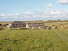
 Pentire Farm | |
Location within
Cornwall | |
| Unitary authority | |
| Ceremonial county | |
| Region | |
| Country | England |
| Sovereign state | United Kingdom |
| Police | Devon and Cornwall |
| Fire | Cornwall |
| Ambulance | South Western |
Pentire ( Cornish: Pentir, meaning promontory) is a farm near St Eval in Cornwall, England. On the coast nearby is Pentire Steps. [1]
It should not be confused with Pentire, a western suburb of Newquay (grid ref. SW7961).
See also
References
- ^ Ordnance Survey: Landranger map sheet 200 Newquay & Bodmin (Map). Ordnance Survey. ISBN 978-0-319-22938-5.
Pentire
| |
|---|---|
 Pentire Farm | |
Location within
Cornwall | |
| Unitary authority | |
| Ceremonial county | |
| Region | |
| Country | England |
| Sovereign state | United Kingdom |
| Police | Devon and Cornwall |
| Fire | Cornwall |
| Ambulance | South Western |
Pentire ( Cornish: Pentir, meaning promontory) is a farm near St Eval in Cornwall, England. On the coast nearby is Pentire Steps. [1]
It should not be confused with Pentire, a western suburb of Newquay (grid ref. SW7961).
See also
References
- ^ Ordnance Survey: Landranger map sheet 200 Newquay & Bodmin (Map). Ordnance Survey. ISBN 978-0-319-22938-5.
