Photos • Location
You can help expand this article with text translated from
the corresponding article in Lithuanian. (October 2011) Click [show] for important translation instructions.
|
| Pelyša | |
|---|---|
 | |
| Location | |
| Country | Lithuania |
| Location | Anykščiai district municipality, Utena County |
| Physical characteristics | |
| Mouth | Šventoji |
• coordinates | 55°38′51″N 25°06′19″E / 55.6475°N 25.1053°E |
| Basin features | |
| Progression | Šventoji→ Neris→ Neman→ Baltic Sea |
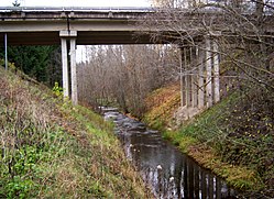
The Pelyša is a river of Anykščiai district municipality, Utena County, in northeastern Lithuania. It flows for 19.3 kilometres and has a basin area of 109.2 km2.
The Pelyša is a right tributary of the Šventoji.
- LIETUVOS RESPUBLIKOS UPIŲ IR TVENKINIŲ KLASIFIKATORIUS (Republic of Lithuania- River and Pond Classifications). Ministry of Environment (Lithuania). Accessed 2011-11-14.
You can help expand this article with text translated from
the corresponding article in Lithuanian. (October 2011) Click [show] for important translation instructions.
|
| Pelyša | |
|---|---|
 | |
| Location | |
| Country | Lithuania |
| Location | Anykščiai district municipality, Utena County |
| Physical characteristics | |
| Mouth | Šventoji |
• coordinates | 55°38′51″N 25°06′19″E / 55.6475°N 25.1053°E |
| Basin features | |
| Progression | Šventoji→ Neris→ Neman→ Baltic Sea |
The Pelyša is a river of Anykščiai district municipality, Utena County, in northeastern Lithuania. It flows for 19.3 kilometres and has a basin area of 109.2 km2.
The Pelyša is a right tributary of the Šventoji.
- LIETUVOS RESPUBLIKOS UPIŲ IR TVENKINIŲ KLASIFIKATORIUS (Republic of Lithuania- River and Pond Classifications). Ministry of Environment (Lithuania). Accessed 2011-11-14.