Photos • Location

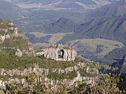
Pedra Furada, a stone photographed from the summit of Morro da Igreja.
28°08′02.49″S 49°28′45.65″W / 28.1340250°S 49.4793472°W

Pedra Furada (Portuguese pronunciation: [ˈpɛdɾɐ fuˈɾadɐ], literally Drilled Stone) is a naturally formed rock arch located in the municipality of Urubici, state of Santa Catarina, Southern Brazil.
It can be spotted from the summit of a mountain named Morro da Igreja.
- (in Portuguese) Portal Urubici
28°08′02.49″S 49°28′45.65″W / 28.1340250°S 49.4793472°W

Pedra Furada (Portuguese pronunciation: [ˈpɛdɾɐ fuˈɾadɐ], literally Drilled Stone) is a naturally formed rock arch located in the municipality of Urubici, state of Santa Catarina, Southern Brazil.
It can be spotted from the summit of a mountain named Morro da Igreja.
- (in Portuguese) Portal Urubici