| Paria Point | |
|---|---|
,_Paria_Point_near_sunset,_Kolob_Canyons,_Zion_National_Park,_sw_Utah_5_(8425006444).jpg) Southwest aspect at sunset | |
| Highest point | |
| Elevation | 7,802 ft (2,378 m) [1] |
| Prominence | 82 ft (25 m) [1] |
| Parent peak | Buck Pasture Mountain (8,030 ft) [1] |
| Isolation | 1.05 mi (1.69 km) [1] |
| Coordinates | 37°27′24″N 113°10′43″W / 37.4566465°N 113.1785599°W [2] |
| Geography | |
 Paria Point Location in Utah  Paria Point Paria Point (the United States) | |
| Country | United States |
| State | Utah |
| County | Washington |
| Protected area | Zion National Park |
| Parent range | Colorado Plateau |
| Topo map | USGS Kolob Arch |
| Geology | |
| Age of rock | Jurassic |
| Type of rock | Navajo sandstone |
| Climbing | |
| Easiest route | class 2 scrambling [1] |
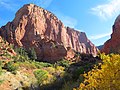
Paria Point is a 7,802-foot (2,378 m) elevation summit located in the Kolob Canyons section of Zion National Park, in Washington County, Utah, United States. [2] Tucupit Point is situated 0.5 mi (0.80 km) immediately north, and Beatty Point is 0.5 mi (0.80 km) immediately south, with 2,000-foot-deep finger canyons between each. Other neighbors include Nagunt Mesa and Timber Top Mountain to the south, and Horse Ranch Mountain to the north. Paria Point is composed of Jurassic Navajo sandstone overlaying tilted Kayenta Formation. Precipitation runoff drains into Taylor Creek, which is part of the Virgin River drainage basin. This feature's paria name is a Paiute word meaning "muddy water" or "elk water". [3]
Climate
Spring and fall are the most favorable seasons to visit Paria Point. According to the Köppen climate classification system, it is located in a Cold semi-arid climate zone, which is defined by the coldest month having an average mean temperature below 32 °F (0 °C), and at least 50% of the total annual precipitation being received during the spring and summer. This desert climate receives less than 10 inches (250 millimeters) of annual rainfall, and snowfall is generally light during the winter. [4]
Gallery
-
 Southwest aspect
 -
 Southwest aspect
 -
 West aspect
 -
 Southwest aspect
 -
 Southwest aspect
 -
 Northwest aspect
 -
 Horse Ranch Mountain, Tucupit Point, and Paria Point from west
 -
 Southwest aspect


_11_(8425011442).jpg)
,_Paria_Point,_Kolob_Canyons,_Zion_National_Park,_sw_Utah_1_(8423915043).jpg)

.jpg)

,_Paria_Point_near_sunset,_Kolob_Canyons,_Zion_National_Park,_sw_Utah_4_(8425006662).jpg)
See also
References
- ^ a b c d e "Paria Point - 7,802' UT". listsofjohn.com. Retrieved 2020-10-18.
- ^ a b U.S. Geological Survey Geographic Names Information System: Paria Point
- ^ Sandy Nestor, Indian Placenames in America, Volume 1, 2003, McFarland & Company Publishers, page 161
- ^ "Zion National Park, Utah, USA - Monthly weather forecast and Climate data". Weather Atlas. Archived from the original on January 27, 2019. Retrieved 31 August 2020.
External links
- Zion National Park National Park Service
- Weather forecast: Paria Point
- Paria Point rock climbing: Mountainproject.com
| Paria Point | |
|---|---|
|
Southwest aspect at sunset | |
| Highest point | |
| Elevation | 7,802 ft (2,378 m) [1] |
| Prominence | 82 ft (25 m) [1] |
| Parent peak | Buck Pasture Mountain (8,030 ft) [1] |
| Isolation | 1.05 mi (1.69 km) [1] |
| Coordinates | 37°27′24″N 113°10′43″W / 37.4566465°N 113.1785599°W [2] |
| Geography | |
Paria Point Location in Utah Paria Point Paria Point (the United States) | |
| Country | United States |
| State | Utah |
| County | Washington |
| Protected area | Zion National Park |
| Parent range | Colorado Plateau |
| Topo map | USGS Kolob Arch |
| Geology | |
| Age of rock | Jurassic |
| Type of rock | Navajo sandstone |
| Climbing | |
| Easiest route | class 2 scrambling [1] |
Paria Point is a 7,802-foot (2,378 m) elevation summit located in the Kolob Canyons section of Zion National Park, in Washington County, Utah, United States. [2] Tucupit Point is situated 0.5 mi (0.80 km) immediately north, and Beatty Point is 0.5 mi (0.80 km) immediately south, with 2,000-foot-deep finger canyons between each. Other neighbors include Nagunt Mesa and Timber Top Mountain to the south, and Horse Ranch Mountain to the north. Paria Point is composed of Jurassic Navajo sandstone overlaying tilted Kayenta Formation. Precipitation runoff drains into Taylor Creek, which is part of the Virgin River drainage basin. This feature's paria name is a Paiute word meaning "muddy water" or "elk water". [3]
Climate
Spring and fall are the most favorable seasons to visit Paria Point. According to the Köppen climate classification system, it is located in a Cold semi-arid climate zone, which is defined by the coldest month having an average mean temperature below 32 °F (0 °C), and at least 50% of the total annual precipitation being received during the spring and summer. This desert climate receives less than 10 inches (250 millimeters) of annual rainfall, and snowfall is generally light during the winter. [4]
Gallery
-
Southwest aspect
-
Southwest aspect
-
West aspect
-
Southwest aspect
-
Southwest aspect
-
Northwest aspect
-
Horse Ranch Mountain, Tucupit Point, and Paria Point from west
-
Southwest aspect
See also
References
- ^ a b c d e "Paria Point - 7,802' UT". listsofjohn.com. Retrieved 2020-10-18.
- ^ a b U.S. Geological Survey Geographic Names Information System: Paria Point
- ^ Sandy Nestor, Indian Placenames in America, Volume 1, 2003, McFarland & Company Publishers, page 161
- ^ "Zion National Park, Utah, USA - Monthly weather forecast and Climate data". Weather Atlas. Archived from the original on January 27, 2019. Retrieved 31 August 2020.
External links
- Zion National Park National Park Service
- Weather forecast: Paria Point
- Paria Point rock climbing: Mountainproject.com