Panola is an unincorporated community in Panola County, Texas, United States. According to the Handbook of Texas, the community had an estimated population of 296 in 2000. [1]
Panola is located at the junction of U.S. Highway 79 and FM 9 in northeastern Panola County, approximately 20 miles northeast of Carthage. [1] Panola has a post office with the ZIP code 75685. [2]
Education
Public education in the community of Panola is provided by the Elysian Fields Independent School District.
References
- ^ a b "Panola, Texas". The Handbook of Texas online. Retrieved November 1, 2009.
- ^ USPS – Cities by ZIP Code
External links
- U.S. Geological Survey Geographic Names Information System: Panola, Texas
- Panola, Texas from the Handbook of Texas Online
Municipalities and communities of
Panola County, Texas, United States | ||
|---|---|---|
| Cities | 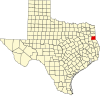 | |
| Town | ||
|
Unincorporated communities | ||
| Ghost town | ||
| Footnotes | ‡This populated place also has portions in an adjacent county or counties | |
Panola is an unincorporated community in Panola County, Texas, United States. According to the Handbook of Texas, the community had an estimated population of 296 in 2000. [1]
Panola is located at the junction of U.S. Highway 79 and FM 9 in northeastern Panola County, approximately 20 miles northeast of Carthage. [1] Panola has a post office with the ZIP code 75685. [2]
Education
Public education in the community of Panola is provided by the Elysian Fields Independent School District.
References
- ^ a b "Panola, Texas". The Handbook of Texas online. Retrieved November 1, 2009.
- ^ USPS – Cities by ZIP Code
External links
- U.S. Geological Survey Geographic Names Information System: Panola, Texas
- Panola, Texas from the Handbook of Texas Online
Municipalities and communities of
Panola County, Texas, United States | ||
|---|---|---|
| Cities | | |
| Town | ||
|
Unincorporated communities | ||
| Ghost town | ||
| Footnotes | ‡This populated place also has portions in an adjacent county or counties | |