Panjagutta | |
|---|---|
Neighbourhood | |
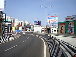
 New twin flyovers at Panjagutta circle | |
| Coordinates: 17°26′12″N 78°26′38″E / 17.436793°N 78.443906°E | |
| Country | |
| State | Telangana |
| District | Hyderabad |
| Metro | Hyderabad |
| Ward | 5 |
| Government | |
| • Body | GHMC |
| Languages | |
| • Official | Telugu |
| Time zone | UTC+5:30 ( IST) |
| PIN | 500082 |
| Vehicle registration | TS |
| Parliament constituencies | Secunderabad |
| Sasana Sabha constituencies | Khairtabad |
| Planning agency | GHMC |
| Website |
telangana |
Panjagutta is a commercial and residential area in western Hyderabad, India. [1] [2] The area contains IT hubs, shopping malls and jewellery shops. It is a major transit point for traffic between the Hyderabad districts of Ameerpet, Banjara hills, Somajiguda and Khairtabad. Twin flyovers across the road junction ease the previously heavy traffic flow. [3]
The name Panjagutta means hand-mountain in Telugu, after a nearby peak.[ citation needed]
- Nizam's Institute of Medical Sciences (NIMS) is also situated in here.
- Hamstech Institute of Fashion & Interior Design is located here.
Hyderabad Metro has a metro station there to connect it to other parts of city. [4] The buses run by TSRTC connect Panjagutta to all parts of the city. There is also a mini-bus service called Setwin service. The closest MMTS Train station is at Begumpet. BSNL office is situated in Durganagar Colony.
Panjagutta | |
|---|---|
Neighbourhood | |
 New twin flyovers at Panjagutta circle | |
| Coordinates: 17°26′12″N 78°26′38″E / 17.436793°N 78.443906°E | |
| Country | |
| State | Telangana |
| District | Hyderabad |
| Metro | Hyderabad |
| Ward | 5 |
| Government | |
| • Body | GHMC |
| Languages | |
| • Official | Telugu |
| Time zone | UTC+5:30 ( IST) |
| PIN | 500082 |
| Vehicle registration | TS |
| Parliament constituencies | Secunderabad |
| Sasana Sabha constituencies | Khairtabad |
| Planning agency | GHMC |
| Website |
telangana |
Panjagutta is a commercial and residential area in western Hyderabad, India. [1] [2] The area contains IT hubs, shopping malls and jewellery shops. It is a major transit point for traffic between the Hyderabad districts of Ameerpet, Banjara hills, Somajiguda and Khairtabad. Twin flyovers across the road junction ease the previously heavy traffic flow. [3]
The name Panjagutta means hand-mountain in Telugu, after a nearby peak.[ citation needed]
- Nizam's Institute of Medical Sciences (NIMS) is also situated in here.
- Hamstech Institute of Fashion & Interior Design is located here.
Hyderabad Metro has a metro station there to connect it to other parts of city. [4] The buses run by TSRTC connect Panjagutta to all parts of the city. There is also a mini-bus service called Setwin service. The closest MMTS Train station is at Begumpet. BSNL office is situated in Durganagar Colony.

