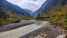
Pangi Valley (Killar) | |
|---|---|
clockwise from top left:pangi valley as seen from kumar village,pasture in pangi valley,shiva peak,sach pass,chandrabhaga river near phindru village . | |
| Coordinates: 33°05′02″N 76°24′25″E / 33.084014°N 76.406980°E | |
| Country | India |
| State | Himachal Pradesh |
| District | Chamba |
| Government | |
| • Type | Himachal Pradesh Legislative Assembly |
| • Body | Janak Raj (politician) |
| Area | |
| • Total | 1,601 km2 (618 sq mi) |
| Population (2011) | |
| • Total | 18,868 |
| • Density | 12/km2 (31/sq mi) |
| Demonym | pangwal |
| Languages | |
| • Official | Hindi |
| • local | Pangwali |
| Time zone | UTC+5:30 ( IST) |
| PIN | 176323 |
| Vehicle registration | HP 45 |
Pangi is a tehsil of Chamba, Himachal Pradesh, India. The Pangi Valley is divided into the sural bhatori, hudan bhatori, kumar bhatori, hilu tuwaan bhatori and chasag bhatori
Bhatori valleys are inhabited at elevations of 7,000 feet (2,100 m) to 11,000 feet (3,400 m) above sea level. The Valley is bordered by Padder, Jammu and Kashmir in North, Lahaul and Spiti in West and Chamba in Southeast. The Sach Pass at the elevation of 4,414m is the only route connecting Pangi with District headquarter Chamba.
References


