Photos • Location
Palo Verde | |||||||||||
|---|---|---|---|---|---|---|---|---|---|---|---|
| Caracas Metro rapid transit station | |||||||||||
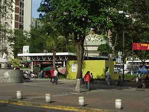
 Entrance to the station | |||||||||||
| General information | |||||||||||
| Location |
Sucre, Miranda | ||||||||||
| Coordinates | 10°28′43.4″N 66°47′54.6″W / 10.478722°N 66.798500°W | ||||||||||
| Operated by | C.A. Metro de Caracas | ||||||||||
| Line(s) | Line 1 | ||||||||||
| Platforms | 2 side platforms | ||||||||||
| Tracks | 2 | ||||||||||
| Connections | |||||||||||
| Construction | |||||||||||
| Structure type | underground | ||||||||||
| History | |||||||||||
| Opened | 10 November 1989 [1] | ||||||||||
| Services | |||||||||||
| |||||||||||
Palo Verde is a Caracas Metro station on Line 1. It was opened on 10 November 1989 as part of the extension of Line 1 from Los Dos Caminos to Palo Verde. It serves as the easter terminus of the line. The adjacent station is Petare. [1]
Palo Verde | |||||||||||
|---|---|---|---|---|---|---|---|---|---|---|---|
| Caracas Metro rapid transit station | |||||||||||
 Entrance to the station | |||||||||||
| General information | |||||||||||
| Location |
Sucre, Miranda | ||||||||||
| Coordinates | 10°28′43.4″N 66°47′54.6″W / 10.478722°N 66.798500°W | ||||||||||
| Operated by | C.A. Metro de Caracas | ||||||||||
| Line(s) | Line 1 | ||||||||||
| Platforms | 2 side platforms | ||||||||||
| Tracks | 2 | ||||||||||
| Connections | |||||||||||
| Construction | |||||||||||
| Structure type | underground | ||||||||||
| History | |||||||||||
| Opened | 10 November 1989 [1] | ||||||||||
| Services | |||||||||||
| |||||||||||
Palo Verde is a Caracas Metro station on Line 1. It was opened on 10 November 1989 as part of the extension of Line 1 from Los Dos Caminos to Palo Verde. It serves as the easter terminus of the line. The adjacent station is Petare. [1]