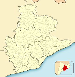
Pallejà | |
|---|---|
 Castell de Pallejà | |
| Coordinates: 41°25′27″N 1°59′52″E / 41.42417°N 1.99778°E | |
| Country | |
| Community | |
| Province | Barcelona |
| Comarca | Baix Llobregat |
| Government | |
| • Mayor | Ascensión Ratia Checa (2015) [1] |
| Area | |
| • Total | 8.3 km2 (3.2 sq mi) |
| Elevation | 41 m (135 ft) |
| Population (2018)
[3] | |
| • Total | 11,486 |
| • Density | 1,400/km2 (3,600/sq mi) |
| Website |
palleja |
Pallejà (Catalan pronunciation: [pəʎəˈʒa]) is a municipality in the comarca of the Baix Llobregat in Catalonia, Spain. It is situated on the right bank of the Llobregat river, on the main N-II road. The main rail lines of the Llobregat corridor pass through the town: the station is served by the FGC services R5/R50, R6, S4 and S8. Pallejà castle was built in the seventeenth century on the site of an older fortress; it currently houses a library.
Demography
| 1900 | 1930 | 1950 | 1970 | 1986 | 2005 |
|---|---|---|---|---|---|
| 656 | 1022 | 1065 | 4081 | 5919 | 10339 |
References
- ^ "Ajuntament de Pallejà". Generalitat of Catalonia. Retrieved 2015-11-13.
- ^ "El municipi en xifres: Pallejà". Statistical Institute of Catalonia. Retrieved 2015-11-23.
- ^ Municipal Register of Spain 2018. National Statistics Institute.
- Panareda Clopés, Josep Maria; Rios Calvet, Jaume; Rabella Vives, Josep Maria (1989). Guia de Catalunya, Barcelona: Caixa de Catalunya. ISBN 84-87135-01-3 (Spanish). ISBN 84-87135-02-1 (Catalan).
External links
- Government data pages (in Catalan)
Pallejà | |
|---|---|
 Castell de Pallejà | |
| Coordinates: 41°25′27″N 1°59′52″E / 41.42417°N 1.99778°E | |
| Country | |
| Community | |
| Province | Barcelona |
| Comarca | Baix Llobregat |
| Government | |
| • Mayor | Ascensión Ratia Checa (2015) [1] |
| Area | |
| • Total | 8.3 km2 (3.2 sq mi) |
| Elevation | 41 m (135 ft) |
| Population (2018)
[3] | |
| • Total | 11,486 |
| • Density | 1,400/km2 (3,600/sq mi) |
| Website |
palleja |
Pallejà (Catalan pronunciation: [pəʎəˈʒa]) is a municipality in the comarca of the Baix Llobregat in Catalonia, Spain. It is situated on the right bank of the Llobregat river, on the main N-II road. The main rail lines of the Llobregat corridor pass through the town: the station is served by the FGC services R5/R50, R6, S4 and S8. Pallejà castle was built in the seventeenth century on the site of an older fortress; it currently houses a library.
Demography
| 1900 | 1930 | 1950 | 1970 | 1986 | 2005 |
|---|---|---|---|---|---|
| 656 | 1022 | 1065 | 4081 | 5919 | 10339 |
References
- ^ "Ajuntament de Pallejà". Generalitat of Catalonia. Retrieved 2015-11-13.
- ^ "El municipi en xifres: Pallejà". Statistical Institute of Catalonia. Retrieved 2015-11-23.
- ^ Municipal Register of Spain 2018. National Statistics Institute.
- Panareda Clopés, Josep Maria; Rios Calvet, Jaume; Rabella Vives, Josep Maria (1989). Guia de Catalunya, Barcelona: Caixa de Catalunya. ISBN 84-87135-01-3 (Spanish). ISBN 84-87135-02-1 (Catalan).
External links
- Government data pages (in Catalan)


