| Pagasetic Gulf | |
|---|---|
| Παγασητικός Κόλπος ( Greek) | |
 The eastern side of the Pagasetic Gulf. | |
| Coordinates | 39°15′N 23°00′E / 39.250°N 23.000°E |
| Type | Gulf |
| Part of | Aegean Sea ( Mediterranean) |
| Primary inflows | Amphrysus |
| Basin countries | Greece |
| Surface area | 175 km2 (68 sq mi) |
| Max. depth | 102 m (335 ft) |
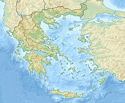
The Pagasetic Gulf ( Greek: Παγασητικός Κόλπος, romanized: Pagasitikós Kólpos) is a rounded gulf (max. depth 102 metres) in the Magnesia regional unit (east central Greece) that is formed by the Mount Pelion peninsula. It is connected with the Euboic Sea. The passage into the Euboic Sea is narrow and is about 4 km.
Its main port is Volos.
Mythology and history
The gulf is named after its historic major port, Pagasae, from which mythology says that Jason built his ship the Argo and from which he sailed on his adventurous voyage. [1]
The gulf's name in Latin was Pagasaeus Sinus. [2]
Places within the gulf
In clockwise order:
- Amaliapolis, W, port
- Alos, W, no port
- Almyros, W, no port
- Nea Anchialos, NW, beach, port,
- Pagasae, NW, no port
- Demetrias, NW, no port
- Iolkos, NW, no port
- Volos, N, main port
- Agria, NE, beach, port
- Neochori, E, no port,
- Argalasti, E, no port, beaches (Lefokastro, Kalamos, Horto)
- Milina, SE, no port, beaches
- Trikeri, S, port at Agia Kyriaki, beaches
The gulf took its name from the ancient city of Pagasae.
References
-
^
 Smith, William, ed. (1854–1857). "Pagasae".
Dictionary of Greek and Roman Geography. London: John Murray.
-
^
 Smith, William, ed. (1854–1857). "Pagasaeus Sinus".
Dictionary of Greek and Roman Geography. London: John Murray.
| Pagasetic Gulf | |
|---|---|
| Παγασητικός Κόλπος ( Greek) | |
 The eastern side of the Pagasetic Gulf. | |
| Coordinates | 39°15′N 23°00′E / 39.250°N 23.000°E |
| Type | Gulf |
| Part of | Aegean Sea ( Mediterranean) |
| Primary inflows | Amphrysus |
| Basin countries | Greece |
| Surface area | 175 km2 (68 sq mi) |
| Max. depth | 102 m (335 ft) |
The Pagasetic Gulf ( Greek: Παγασητικός Κόλπος, romanized: Pagasitikós Kólpos) is a rounded gulf (max. depth 102 metres) in the Magnesia regional unit (east central Greece) that is formed by the Mount Pelion peninsula. It is connected with the Euboic Sea. The passage into the Euboic Sea is narrow and is about 4 km.
Its main port is Volos.
Mythology and history
The gulf is named after its historic major port, Pagasae, from which mythology says that Jason built his ship the Argo and from which he sailed on his adventurous voyage. [1]
The gulf's name in Latin was Pagasaeus Sinus. [2]
Places within the gulf
In clockwise order:
- Amaliapolis, W, port
- Alos, W, no port
- Almyros, W, no port
- Nea Anchialos, NW, beach, port,
- Pagasae, NW, no port
- Demetrias, NW, no port
- Iolkos, NW, no port
- Volos, N, main port
- Agria, NE, beach, port
- Neochori, E, no port,
- Argalasti, E, no port, beaches (Lefokastro, Kalamos, Horto)
- Milina, SE, no port, beaches
- Trikeri, S, port at Agia Kyriaki, beaches
The gulf took its name from the ancient city of Pagasae.
References
-
^
 Smith, William, ed. (1854–1857). "Pagasae".
Dictionary of Greek and Roman Geography. London: John Murray.
-
^
 Smith, William, ed. (1854–1857). "Pagasaeus Sinus".
Dictionary of Greek and Roman Geography. London: John Murray.
