Pag Bridge Paški most | |
|---|---|
 | |
| Coordinates | 44°19′30″N 15°15′29″E / 44.325°N 15.258°E |
| Carries | D106 road |
| Crosses | Ljubačka Vrata Strait |
| Locale | Zadar County, Croatia |
| Named for | Island of Pag |
| Maintained by | Hrvatske ceste |
| Characteristics | |
| Design | concrete arch bridge |
| Total length | 301 m |
| Width | 9 m |
| Longest span | 201 m |
| Clearance below | 35 m |
| History | |
| Opened | 1968 |
| Location | |
|
| |
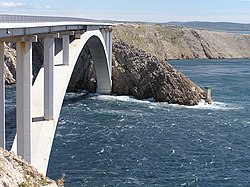
The Pag Bridge ( Croatian: Paški most) is the bridge that connects the island of Pag to the Croatian mainland. It is a 301 meters (988 ft) long, 9 meters (30 ft) wide bridge whose 201 meters (659 ft) long arch rises 35 meters (115 ft) above an Adriatic Sea strait called Ljubačka Vrata. [1] It was opened on 17 November 1968, and it transformed life on the island of Pag to be able to function more as a peninsula. [1]
The bridge was built by the local company Mostogradnja, designed by civil engineer Ilija Stojadinović, who also designed the nearby Šibenik Bridge. [1] The location of the bridge near Velebit causes the bridge to endure strong gusts of wind, the bora, and during the construction the wind speed was 8 on the Beaufort scale for a period of four months. [1] In a 2019 spring storm, the top wind speed on the bridge was 198 kilometres per hour (123 mph). [2]
- Festini, Alenka (7 February 2008). "Paški most slavi 40. rođendan". Zadarski list (in Croatian). Retrieved 14 May 2019.
- "Nevrijeme u Hrvatskoj od 12. do 14. svibnja 2019" (in Croatian). Croatian Meteorological and Hydrological Service. 14 May 2019. Retrieved 15 May 2019.
Pag Bridge Paški most | |
|---|---|
 | |
| Coordinates | 44°19′30″N 15°15′29″E / 44.325°N 15.258°E |
| Carries | D106 road |
| Crosses | Ljubačka Vrata Strait |
| Locale | Zadar County, Croatia |
| Named for | Island of Pag |
| Maintained by | Hrvatske ceste |
| Characteristics | |
| Design | concrete arch bridge |
| Total length | 301 m |
| Width | 9 m |
| Longest span | 201 m |
| Clearance below | 35 m |
| History | |
| Opened | 1968 |
| Location | |
|
| |
The Pag Bridge ( Croatian: Paški most) is the bridge that connects the island of Pag to the Croatian mainland. It is a 301 meters (988 ft) long, 9 meters (30 ft) wide bridge whose 201 meters (659 ft) long arch rises 35 meters (115 ft) above an Adriatic Sea strait called Ljubačka Vrata. [1] It was opened on 17 November 1968, and it transformed life on the island of Pag to be able to function more as a peninsula. [1]
The bridge was built by the local company Mostogradnja, designed by civil engineer Ilija Stojadinović, who also designed the nearby Šibenik Bridge. [1] The location of the bridge near Velebit causes the bridge to endure strong gusts of wind, the bora, and during the construction the wind speed was 8 on the Beaufort scale for a period of four months. [1] In a 2019 spring storm, the top wind speed on the bridge was 198 kilometres per hour (123 mph). [2]
- Festini, Alenka (7 February 2008). "Paški most slavi 40. rođendan". Zadarski list (in Croatian). Retrieved 14 May 2019.
- "Nevrijeme u Hrvatskoj od 12. do 14. svibnja 2019" (in Croatian). Croatian Meteorological and Hydrological Service. 14 May 2019. Retrieved 15 May 2019.