Photos • Location
Pšenična Polica | |
|---|---|
 | |
| Coordinates: 46°14′52″N 14°29′54.6″E / 46.24778°N 14.498500°E | |
| Country |
|
| Traditional Region | Upper Carniola |
| Statistical region | Upper Carniola |
| Municipality | Cerklje na Gorenjskem |
| Elevation | 386.9 m (1,269.4 ft) |
| Population (2020) | |
| • Total | 114 |
| [1] | |
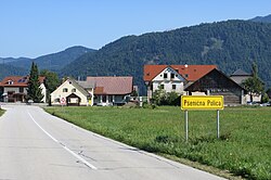
Pšenična Polica (pronounced [pʃɛˈniːtʃna pɔˈliːtsa]; German: Niederfeld [2]) is a settlement in the Municipality of Cerklje na Gorenjskem in the Upper Carniola region of Slovenia.
References
- ^ Statistical Office of the Republic of Slovenia
- ^ Leksikon občin kraljestev in dežel zastopanih v državnem zboru, vol. 6: Kranjsko. 1906. Vienna: C. Kr. Dvorna in Državna Tiskarna, p. 52.
External links
-
 Media related to
Pšenična Polica at Wikimedia Commons
 - Pšenična Polica on Geopedia
Pšenična Polica | |
|---|---|
 | |
| Coordinates: 46°14′52″N 14°29′54.6″E / 46.24778°N 14.498500°E | |
| Country |
|
| Traditional Region | Upper Carniola |
| Statistical region | Upper Carniola |
| Municipality | Cerklje na Gorenjskem |
| Elevation | 386.9 m (1,269.4 ft) |
| Population (2020) | |
| • Total | 114 |
| [1] | |
Pšenična Polica (pronounced [pʃɛˈniːtʃna pɔˈliːtsa]; German: Niederfeld [2]) is a settlement in the Municipality of Cerklje na Gorenjskem in the Upper Carniola region of Slovenia.
References
- ^ Statistical Office of the Republic of Slovenia
- ^ Leksikon občin kraljestev in dežel zastopanih v državnem zboru, vol. 6: Kranjsko. 1906. Vienna: C. Kr. Dvorna in Državna Tiskarna, p. 52.
External links
-
 Media related to
Pšenična Polica at Wikimedia Commons
 - Pšenična Polica on Geopedia

