Photos • Location
Owyhee Reservoir State Airport | |||||||||||
|---|---|---|---|---|---|---|---|---|---|---|---|
 | |||||||||||
| Summary | |||||||||||
| Airport type | Public | ||||||||||
| Operator | Oregon Department of Aviation | ||||||||||
| Location | Owyhee, Oregon | ||||||||||
| Elevation AMSL | 2,680 ft / 817 m | ||||||||||
| Coordinates | 43°25′29.5730″N 117°20′43.58″W / 43.424881389°N 117.3454389°W | ||||||||||
| Runways | |||||||||||
| |||||||||||
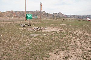
Owyhee Reservoir State Airport ( FAA LID: 28U) is a public airport located 25 miles (40 km) southwest of Owyhee, in Malheur County, Oregon, United States.
See also
External links
- Resources for this airport:
- FAA airport information for 28U
- AirNav airport information for 28U
- FlightAware airport information and live flight tracker
- SkyVector aeronautical chart for 28U
Owyhee Reservoir State Airport | |||||||||||
|---|---|---|---|---|---|---|---|---|---|---|---|
 | |||||||||||
| Summary | |||||||||||
| Airport type | Public | ||||||||||
| Operator | Oregon Department of Aviation | ||||||||||
| Location | Owyhee, Oregon | ||||||||||
| Elevation AMSL | 2,680 ft / 817 m | ||||||||||
| Coordinates | 43°25′29.5730″N 117°20′43.58″W / 43.424881389°N 117.3454389°W | ||||||||||
| Runways | |||||||||||
| |||||||||||
Owyhee Reservoir State Airport ( FAA LID: 28U) is a public airport located 25 miles (40 km) southwest of Owyhee, in Malheur County, Oregon, United States.
See also
External links
- Resources for this airport:
- FAA airport information for 28U
- AirNav airport information for 28U
- FlightAware airport information and live flight tracker
- SkyVector aeronautical chart for 28U