Ostrowo | |
|---|---|
Village | |
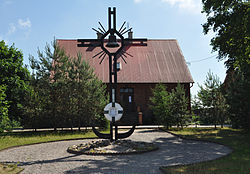
 Chapel in Ostrowo | |
| Coordinates: 54°49′31″N 18°14′42″E / 54.82528°N 18.24500°E | |
| Country | |
| Voivodeship | Pomeranian |
| County | Puck |
| Gmina | Władysławowo |
| Population | 605 |
| Time zone | UTC+1 ( CET) |
| • Summer ( DST) | UTC+2 ( CEST) |
| Vehicle registration | GPU |
Ostrowo is a village in the administrative district of Gmina Władysławowo, within Puck County, Pomeranian Voivodeship, in northern Poland. It lies approximately 1 km (1 mi) south of the Baltic Sea, 11 km (7 mi) west of Władysławowo, 16 km (10 mi) north-west of Puck, and 60 km (37 mi) north-west of the regional capital Gdańsk. It is located within the ethnocultural region of Kashubia in the historic region of Pomerania. Prior to January 1, 2015, it was a part of the town Władysławowo. [1]
History
Ostrowo was a royal village of the Polish Crown, administratively located in the Puck County in the Pomeranian Voivodeship. [2] In 1552 King Sigismund II Augustus renewed the old lost privilege of the village, which was later confirmed by Kings Władysław IV Vasa, John II Casimir Vasa and John III Sobieski. [3]
References
- ^ Rozporządzenie Rady Ministrów z dnia 29 lipca 2014 r. w sprawie połączenia gmin, ustalenia granic niektórych gmin i miast, nadania niektórym miejscowościom statusu miasta oraz zmiany siedziby władz gminy, Dz. U. z 2014 r. poz. 1023 (2014-07-29)
-
^ Biskup, Marian; Tomczak, Andrzej (1955). Mapy województwa pomorskiego w drugiej połowie XVI w. (in Polish). Toruń. p. 100.
{{
cite book}}
: CS1 maint: location missing publisher ( link) -
^ Słownik geograficzny Królestwa Polskiego i innych krajów słowiańskich, Tom VII (in Polish). Warsaw. 1886. p. 727.
{{
cite book}}
: CS1 maint: location missing publisher ( link)
Ostrowo | |
|---|---|
Village | |
 Chapel in Ostrowo | |
| Coordinates: 54°49′31″N 18°14′42″E / 54.82528°N 18.24500°E | |
| Country | |
| Voivodeship | Pomeranian |
| County | Puck |
| Gmina | Władysławowo |
| Population | 605 |
| Time zone | UTC+1 ( CET) |
| • Summer ( DST) | UTC+2 ( CEST) |
| Vehicle registration | GPU |
Ostrowo is a village in the administrative district of Gmina Władysławowo, within Puck County, Pomeranian Voivodeship, in northern Poland. It lies approximately 1 km (1 mi) south of the Baltic Sea, 11 km (7 mi) west of Władysławowo, 16 km (10 mi) north-west of Puck, and 60 km (37 mi) north-west of the regional capital Gdańsk. It is located within the ethnocultural region of Kashubia in the historic region of Pomerania. Prior to January 1, 2015, it was a part of the town Władysławowo. [1]
History
Ostrowo was a royal village of the Polish Crown, administratively located in the Puck County in the Pomeranian Voivodeship. [2] In 1552 King Sigismund II Augustus renewed the old lost privilege of the village, which was later confirmed by Kings Władysław IV Vasa, John II Casimir Vasa and John III Sobieski. [3]
References
- ^ Rozporządzenie Rady Ministrów z dnia 29 lipca 2014 r. w sprawie połączenia gmin, ustalenia granic niektórych gmin i miast, nadania niektórym miejscowościom statusu miasta oraz zmiany siedziby władz gminy, Dz. U. z 2014 r. poz. 1023 (2014-07-29)
-
^ Biskup, Marian; Tomczak, Andrzej (1955). Mapy województwa pomorskiego w drugiej połowie XVI w. (in Polish). Toruń. p. 100.
{{
cite book}}
: CS1 maint: location missing publisher ( link) -
^ Słownik geograficzny Królestwa Polskiego i innych krajów słowiańskich, Tom VII (in Polish). Warsaw. 1886. p. 727.
{{
cite book}}
: CS1 maint: location missing publisher ( link)

