Photos • Location
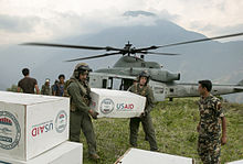
Relief efforts in Orang after the
May 2015 Nepal earthquake (
Operation Sahayogi Haat)

Orang, Nepal
ओराङ | |
|---|---|
 Orang, Nepal Location in Nepal | |
| Coordinates: 27°49′N 86°12′E / 27.81°N 86.20°E | |
| Country | |
| Zone | Janakpur Zone |
| District | Dolakha District |
| Population (1991) | |
| • Total | 1,771 |
| Time zone | UTC+5:45 ( Nepal Time) |
Orang, Nepal is a village development committee in Dolakha District in the Janakpur Zone of north-eastern Nepal. At the time of the 1991 Nepal census it had a population of 1,771 people living in 378 individual households. [1]

References
- ^ "Nepal Census 2001", Nepal's Village Development Committees, Digital Himalaya, archived from the original on October 12, 2008, retrieved 15 November 2009.
External links
|  | |||||||
|
|
| This article about a location in the Dolakha District of Nepal is a stub. You can help Wikipedia by expanding it. |
Orang, Nepal
ओराङ | |
|---|---|
Orang, Nepal Location in Nepal | |
| Coordinates: 27°49′N 86°12′E / 27.81°N 86.20°E | |
| Country | |
| Zone | Janakpur Zone |
| District | Dolakha District |
| Population (1991) | |
| • Total | 1,771 |
| Time zone | UTC+5:45 ( Nepal Time) |
Orang, Nepal is a village development committee in Dolakha District in the Janakpur Zone of north-eastern Nepal. At the time of the 1991 Nepal census it had a population of 1,771 people living in 378 individual households. [1]
References
- ^ "Nepal Census 2001", Nepal's Village Development Committees, Digital Himalaya, archived from the original on October 12, 2008, retrieved 15 November 2009.
External links
| | |||||||
| ||||||||
|
| This article about a location in the Dolakha District of Nepal is a stub. You can help Wikipedia by expanding it. |