Photos • Location

Neighbourhood of the Saint-Etienne church

.JPG)
Ohain (French pronunciation: [ɔ.ɛ̃] ; Walloon: Ohin) is a Belgian village and district of the municipality of Lasne, Wallonia in the province of Walloon Brabant.
Gallery
-
 Pulpit of the church of Saint-Etienne
 -
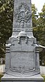 War monument
 -
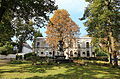 Place Communale


.JPG)
References
External links
-
 Media related to
Ohain, Belgium at Wikimedia Commons
Media related to
Ohain, Belgium at Wikimedia Commons
50°42′N 4°28′E / 50.700°N 4.467°E
|
| This Walloon Brabant location article is a stub. You can help Wikipedia by expanding it. |
Ohain (French pronunciation: [ɔ.ɛ̃] ; Walloon: Ohin) is a Belgian village and district of the municipality of Lasne, Wallonia in the province of Walloon Brabant.
Gallery
-
Pulpit of the church of Saint-Etienne
-
War monument
-
Place Communale
References
External links
-
Media related to
Ohain, Belgium at Wikimedia Commons
50°42′N 4°28′E / 50.700°N 4.467°E
|
| This Walloon Brabant location article is a stub. You can help Wikipedia by expanding it. |