Oerlinghausen | |
|---|---|
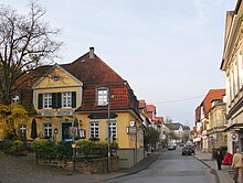
 A view of Oerlinghausen | |
Location of Oerlinghausen within Lippe district  | |
| Coordinates: 51°58′00″N 08°40′00″E / 51.96667°N 8.66667°E | |
| Country | Germany |
| State | North Rhine-Westphalia |
| Admin. region | Detmold |
| District | Lippe |
| Government | |
| • Mayor (2020–25) | Dirk Becker [1] ( SPD) |
| Area | |
| • Total | 32.69 km2 (12.62 sq mi) |
| Elevation | 214 m (702 ft) |
| Population (2022-12-31)
[2] | |
| • Total | 17,238 |
| • Density | 530/km2 (1,400/sq mi) |
| Time zone | UTC+01:00 ( CET) |
| • Summer ( DST) | UTC+02:00 ( CEST) |
| Postal codes | 33813 |
| Dialling codes | 05202 |
| Vehicle registration | LIP |
| Website | oerlinghausen.de |
Oerlinghausen (German pronunciation: [ˈœʁlɪŋhaʊzən] ⓘ; Low German: Ankhiusen) is a city in the Lippe district of North Rhine-Westphalia, Germany located between Bielefeld and Detmold in the Teutoburg Forest. At the end of February 2023, it had 17,314 inhabitants. [3]
Geography
Geographically, Oerlinghausen is situated on top of the Teutoburger Forest hills. Oerlinghausen's highest point is the Tönsberg with 334 meters. The flatlands of northern Germany start some 40 km north of Oerlinghausen. There are hiking routes along the hill chain which stretches 80 km in east-west direction. To the south of the hills are large sand areas originating from melting glaciers during past ice ages. Although not high, the hills are steep in many places and almost completely covered by forest.

History and culture
First mentioned in documents in 1036, the town became a city in 1926 by authority of the Land of Lippe. In 1969 the city was expanded with the addition of Helpup, Währentrup and Lipperreihe as part of the "Gebietsreform" movement.
Oerlinghausen is home to an airfield which is one of Europe's largest gliding centres as well as the well known Archäologisches Freilichtmuseum Oerlinghausen ( archaeological open-air museum) featuring reconstructions of a variety of dwellings spanning from 10,000 BC to 1000 AD.
The city has also been home to an unusual number of well-known sociologists. Marianne Weber (born Schnitger), who was born in Oerlinghausen and married Max Weber here in 1893, was a well-respected author herself. Niklas Luhmann and Richard Grathoff, two of the key sociologists who made the Bielefeld University one of the premier institutions for sociology in Europe, have also lived in Oerlinghausen for extended time periods.
Number of inhabitants
| Year | Inhabitants |
|---|---|
| 1968 | 12.839 |
| 1970 | 13.276 |
| 1974 | 14.292 |
| 1975 | 14.474 |
| 1980 | 14.751 |
| 1985 | 14.738 |
| 1987 | 14.757 |
| 1990 | 15.689 |
| 1995 | 17.165 |
| 2000 | 17.465 |
| 2005 | 17.305 |
| 2007 | 16.988 |
| 2012 | 16.654 |
Mayors

| Time of office | Name | Party |
|---|---|---|
| 1926–1933 | August Reuter | |
| 1933–1945 | Friedrich Möller | NSDAP |
| 1945–1946 | August Reuter | |
| 1946–1965 | Heinrich Kramer | SPD |
| 1965–1969 | Heinrich Schildmann | SPD |
| 1969–1975 | Konrad Dreckshage | FDP |
| 1975–1984 | Erich Diekhof | SPD |
| 1984–1989 | Horst Steinkühler | SPD |
| 1989–1999 | Martin Weber | SPD |
| 1999–2015 | Ursula Herbort | independent |
| since 2015 | Dirk Becker | SPD |

Sons and daughters of the town
- Marianne Weber (born Schnitger) (1870–1954), lawyer, sociologist and legal historian
- Friedrich Bödeker (1867–1937), craftsman and cacti explorer
- Berthold Müller-Oerlinghausen (1893–1979), sculptor
- Andreas Ortmann (born 1953), economist
References
- ^ Wahlergebnisse in NRW Kommunalwahlen 2020, Land Nordrhein-Westfalen, accessed 21 June 2021.
- ^ "Bevölkerung der Gemeinden Nordrhein-Westfalens am 31. Dezember 2022 – Fortschreibung des Bevölkerungsstandes auf Basis des Zensus vom 9. Mai 2011" (in German). Landesbetrieb Information und Technik NRW. Retrieved 20 June 2023.
- ^ "Bevölkerungsstand nach Geschlecht – Gemeinden – Februar (28. bzw. 29.)", Landesbetrieb Information und Technik Nordrhein-Westfalen
External links
- Official website (in German)
- Freilichtmuseum website (in German)
- Glider Airfield Website (in German)
Oerlinghausen | |
|---|---|
 A view of Oerlinghausen | |
Location of Oerlinghausen within Lippe district  | |
| Coordinates: 51°58′00″N 08°40′00″E / 51.96667°N 8.66667°E | |
| Country | Germany |
| State | North Rhine-Westphalia |
| Admin. region | Detmold |
| District | Lippe |
| Government | |
| • Mayor (2020–25) | Dirk Becker [1] ( SPD) |
| Area | |
| • Total | 32.69 km2 (12.62 sq mi) |
| Elevation | 214 m (702 ft) |
| Population (2022-12-31)
[2] | |
| • Total | 17,238 |
| • Density | 530/km2 (1,400/sq mi) |
| Time zone | UTC+01:00 ( CET) |
| • Summer ( DST) | UTC+02:00 ( CEST) |
| Postal codes | 33813 |
| Dialling codes | 05202 |
| Vehicle registration | LIP |
| Website | oerlinghausen.de |
Oerlinghausen (German pronunciation: [ˈœʁlɪŋhaʊzən] ⓘ; Low German: Ankhiusen) is a city in the Lippe district of North Rhine-Westphalia, Germany located between Bielefeld and Detmold in the Teutoburg Forest. At the end of February 2023, it had 17,314 inhabitants. [3]
Geography
Geographically, Oerlinghausen is situated on top of the Teutoburger Forest hills. Oerlinghausen's highest point is the Tönsberg with 334 meters. The flatlands of northern Germany start some 40 km north of Oerlinghausen. There are hiking routes along the hill chain which stretches 80 km in east-west direction. To the south of the hills are large sand areas originating from melting glaciers during past ice ages. Although not high, the hills are steep in many places and almost completely covered by forest.

History and culture
First mentioned in documents in 1036, the town became a city in 1926 by authority of the Land of Lippe. In 1969 the city was expanded with the addition of Helpup, Währentrup and Lipperreihe as part of the "Gebietsreform" movement.
Oerlinghausen is home to an airfield which is one of Europe's largest gliding centres as well as the well known Archäologisches Freilichtmuseum Oerlinghausen ( archaeological open-air museum) featuring reconstructions of a variety of dwellings spanning from 10,000 BC to 1000 AD.
The city has also been home to an unusual number of well-known sociologists. Marianne Weber (born Schnitger), who was born in Oerlinghausen and married Max Weber here in 1893, was a well-respected author herself. Niklas Luhmann and Richard Grathoff, two of the key sociologists who made the Bielefeld University one of the premier institutions for sociology in Europe, have also lived in Oerlinghausen for extended time periods.
Number of inhabitants
| Year | Inhabitants |
|---|---|
| 1968 | 12.839 |
| 1970 | 13.276 |
| 1974 | 14.292 |
| 1975 | 14.474 |
| 1980 | 14.751 |
| 1985 | 14.738 |
| 1987 | 14.757 |
| 1990 | 15.689 |
| 1995 | 17.165 |
| 2000 | 17.465 |
| 2005 | 17.305 |
| 2007 | 16.988 |
| 2012 | 16.654 |
Mayors

| Time of office | Name | Party |
|---|---|---|
| 1926–1933 | August Reuter | |
| 1933–1945 | Friedrich Möller | NSDAP |
| 1945–1946 | August Reuter | |
| 1946–1965 | Heinrich Kramer | SPD |
| 1965–1969 | Heinrich Schildmann | SPD |
| 1969–1975 | Konrad Dreckshage | FDP |
| 1975–1984 | Erich Diekhof | SPD |
| 1984–1989 | Horst Steinkühler | SPD |
| 1989–1999 | Martin Weber | SPD |
| 1999–2015 | Ursula Herbort | independent |
| since 2015 | Dirk Becker | SPD |

Sons and daughters of the town
- Marianne Weber (born Schnitger) (1870–1954), lawyer, sociologist and legal historian
- Friedrich Bödeker (1867–1937), craftsman and cacti explorer
- Berthold Müller-Oerlinghausen (1893–1979), sculptor
- Andreas Ortmann (born 1953), economist
References
- ^ Wahlergebnisse in NRW Kommunalwahlen 2020, Land Nordrhein-Westfalen, accessed 21 June 2021.
- ^ "Bevölkerung der Gemeinden Nordrhein-Westfalens am 31. Dezember 2022 – Fortschreibung des Bevölkerungsstandes auf Basis des Zensus vom 9. Mai 2011" (in German). Landesbetrieb Information und Technik NRW. Retrieved 20 June 2023.
- ^ "Bevölkerungsstand nach Geschlecht – Gemeinden – Februar (28. bzw. 29.)", Landesbetrieb Information und Technik Nordrhein-Westfalen
External links
- Official website (in German)
- Freilichtmuseum website (in German)
- Glider Airfield Website (in German)


