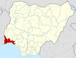
Odeda | |
|---|---|
LGA and town | |
| Motto: Odeda PAPADA | |
| Coordinates: 7°13′N 3°31′E / 7.217°N 3.517°E | |
| Country | |
| State | Ogun State |
| Government | |
| • Local Government Chairman and the Head of the Local Government Council | Folasade Adeyemo ( APC) |
| Area | |
| • Total | 1,560 km2 (600 sq mi) |
| Population (2006 census) | |
| • Total | 109,449 |
| Time zone | UTC+1 ( WAT) |
| 3-digit postal code prefix | 110 |
| ISO 3166 code | NG.OG.OD |
|
| |
Odeda (or Awdeda) is a Local Government Area and town in Ogun State, Nigeria. The headquarters of the LGA are at Odeda on the A5 highway 7°13′00″N 3°31′00″E / 7.21667°N 3.51667°E.
It has an area of 1,560 km2 and a population of 109,449 at the 2006 census. The local government is bounded at Bakatare. A small village close to Oyo State and also bounded at Alogi, a big urban centre that bound the local government area from Abeokuta-south.
The postal code of the area is 110. [1]
References
- ^ "Post Offices- with map of LGA". NIPOST. Archived from the original on October 7, 2009. Retrieved 2009-10-20..

