Photos • Location

Die Lauerquelle, genannt das "Storchenbrünnle"

Jüdischer Friedhof
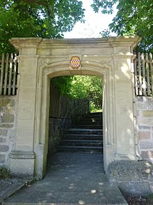
Rückertpforte

This article relies largely or entirely on a
single source. (November 2020) |
Oberlauringen | |
|---|---|
 Oberlauringen  Oberlauringen | |
| Coordinates: 50°12′58″N 10°22′44″E / 50.21611°N 10.37889°E | |
| Country | Germany |
| State | Bavaria |
| Admin. region | Lower Franconia |
| District | Schweinfurt |
| Municipality | Stadtlauringen |
| Elevation | 325 m (1,066 ft) |
| Time zone | UTC+01:00 ( CET) |
| • Summer ( DST) | UTC+02:00 ( CEST) |
| Postal codes | 97488 |
| Dialling codes | 09724 |

Oberlauringen, with 680 inhabitants is part of the municipality Stadtlauringen in the district of Schweinfurt in Lower Franconia, Bavaria, Germany.


History
On May 1, 1978, the previously independent municipality was incorporated into the Stadtlauringen market. [1]
References
- ^ Historisches Gemeindeverzeichnis für die Bundesrepublik Deutschland. Namens-, Grenz- und Schlüsselnummernänderungen bei Gemeinden, Kreisen und Regierungsbezirken vom 27. 5. 1970 bis 31. 12. 1982. W. Kohlhammer GmbH. p. 753. ISBN 3-17-003263-1.
| International | |
|---|---|
| National | |
|
| This Schweinfurt location article is a stub. You can help Wikipedia by expanding it. |
This article relies largely or entirely on a
single source. (November 2020) |
Oberlauringen | |
|---|---|
Oberlauringen Oberlauringen | |
| Coordinates: 50°12′58″N 10°22′44″E / 50.21611°N 10.37889°E | |
| Country | Germany |
| State | Bavaria |
| Admin. region | Lower Franconia |
| District | Schweinfurt |
| Municipality | Stadtlauringen |
| Elevation | 325 m (1,066 ft) |
| Time zone | UTC+01:00 ( CET) |
| • Summer ( DST) | UTC+02:00 ( CEST) |
| Postal codes | 97488 |
| Dialling codes | 09724 |
Oberlauringen, with 680 inhabitants is part of the municipality Stadtlauringen in the district of Schweinfurt in Lower Franconia, Bavaria, Germany.
History
On May 1, 1978, the previously independent municipality was incorporated into the Stadtlauringen market. [1]
References
- ^ Historisches Gemeindeverzeichnis für die Bundesrepublik Deutschland. Namens-, Grenz- und Schlüsselnummernänderungen bei Gemeinden, Kreisen und Regierungsbezirken vom 27. 5. 1970 bis 31. 12. 1982. W. Kohlhammer GmbH. p. 753. ISBN 3-17-003263-1.
| International | |
|---|---|
| National | |
|
| This Schweinfurt location article is a stub. You can help Wikipedia by expanding it. |