Notre-Dame-des-Monts | |
|---|---|
| Motto: D'un mont à l'autre | |
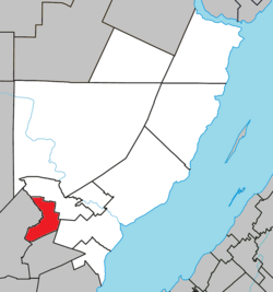
 Location within Charlevoix-Est RCM. | |
| Coordinates: 47°40′N 70°23′W / 47.667°N 70.383°W [1] | |
| Country | |
| Province | |
| Region | Capitale-Nationale |
| RCM | Charlevoix-Est |
| Constituted | April 11, 1935 |
| Government | |
| • Mayor | Jean-Claude Simard |
| • Federal riding |
Montmorency—Charlevoix —Haute-Côte-Nord |
| • Prov. riding | Charlevoix–Côte-de-Beaupré |
| Area | |
| • Total | 57.50 km2 (22.20 sq mi) |
| • Land | 57.44 km2 (22.18 sq mi) |
| Population | |
| • Total | 791 |
| • Density | 13.8/km2 (36/sq mi) |
| • Pop 2011-2016 | |
| • Dwellings | 350 |
| Time zone | UTC−5 ( EST) |
| • Summer ( DST) | UTC−4 ( EDT) |
| Postal code(s) | |
| Area code(s) | 418 and 581 |
| Highways | No major routes |
| Website |
www.notredame desmonts.com |
Notre-Dame-des-Monts is a municipality of Charlevoix-Est Regional County Municipality, in the Capitale-Nationale region of Quebec, Canada.
Geography
As its name suggests, the territory of the municipality is dotted with mountains sometimes reaching 554 metres (1,818 ft). The River du Gouffre forms its western boundary. It has an area of 57.50 kilometres (35.73 mi).
History
The municipality was founded in 1935 under the name of canton de Sales. In 1947 the parish of Notre-Dame-des-Monts was canonically erected, and the municipality took its name the following year. One can observe from the village, a series of mountains resembling a woman lying on her back. The name given to this series of mountains is “La Noyée”. Regional legend says it is the profile of an Indian girl lying on her back, drowned as she crossed Lake Nairne to meet her beloved, a white man from the nearby hamlet.
Demographics
Population
|
|
|
Private dwellings occupied by usual residents: 320 (total dwellings: 350)
Language
Mother tongue:
- English as first language: 0%
- French as first language: 98.6%
- English and French as first language: 0%
- Other as first language: 1.4%
See also
References
- ^ "Banque de noms de lieux du Québec: Reference number 44868". toponymie.gouv.qc.ca (in French). Commission de toponymie du Québec.
- ^ a b Ministère des Affaires municipales, des Régions et de l'Occupation du territoire - Répertoire des municipalités: Notre-Dame-des-Monts
- ^ a b Statistics Canada 2016 Census - Notre-Dame-des-Monts census profile
- ^ Statistics Canada: 1996, 2001, 2006, 2011, 2016 census
Notre-Dame-des-Monts | |
|---|---|
| Motto: D'un mont à l'autre | |
 Location within Charlevoix-Est RCM. | |
| Coordinates: 47°40′N 70°23′W / 47.667°N 70.383°W [1] | |
| Country | |
| Province | |
| Region | Capitale-Nationale |
| RCM | Charlevoix-Est |
| Constituted | April 11, 1935 |
| Government | |
| • Mayor | Jean-Claude Simard |
| • Federal riding |
Montmorency—Charlevoix —Haute-Côte-Nord |
| • Prov. riding | Charlevoix–Côte-de-Beaupré |
| Area | |
| • Total | 57.50 km2 (22.20 sq mi) |
| • Land | 57.44 km2 (22.18 sq mi) |
| Population | |
| • Total | 791 |
| • Density | 13.8/km2 (36/sq mi) |
| • Pop 2011-2016 | |
| • Dwellings | 350 |
| Time zone | UTC−5 ( EST) |
| • Summer ( DST) | UTC−4 ( EDT) |
| Postal code(s) | |
| Area code(s) | 418 and 581 |
| Highways | No major routes |
| Website |
www.notredame desmonts.com |
Notre-Dame-des-Monts is a municipality of Charlevoix-Est Regional County Municipality, in the Capitale-Nationale region of Quebec, Canada.
Geography
As its name suggests, the territory of the municipality is dotted with mountains sometimes reaching 554 metres (1,818 ft). The River du Gouffre forms its western boundary. It has an area of 57.50 kilometres (35.73 mi).
History
The municipality was founded in 1935 under the name of canton de Sales. In 1947 the parish of Notre-Dame-des-Monts was canonically erected, and the municipality took its name the following year. One can observe from the village, a series of mountains resembling a woman lying on her back. The name given to this series of mountains is “La Noyée”. Regional legend says it is the profile of an Indian girl lying on her back, drowned as she crossed Lake Nairne to meet her beloved, a white man from the nearby hamlet.
Demographics
Population
|
|
|
Private dwellings occupied by usual residents: 320 (total dwellings: 350)
Language
Mother tongue:
- English as first language: 0%
- French as first language: 98.6%
- English and French as first language: 0%
- Other as first language: 1.4%
See also
References
- ^ "Banque de noms de lieux du Québec: Reference number 44868". toponymie.gouv.qc.ca (in French). Commission de toponymie du Québec.
- ^ a b Ministère des Affaires municipales, des Régions et de l'Occupation du territoire - Répertoire des municipalités: Notre-Dame-des-Monts
- ^ a b Statistics Canada 2016 Census - Notre-Dame-des-Monts census profile
- ^ Statistics Canada: 1996, 2001, 2006, 2011, 2016 census
