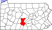
Nossville, Pennsylvania | |
|---|---|
Unincorporated community | |
| Coordinates: 40°14′01″N 77°45′56″W / 40.23361°N 77.76556°W | |
| Country | United States |
| State | Pennsylvania |
| County | Huntingdon |
| Township | Tell |
| Elevation | 860 ft (262 m) |
| Time zone | UTC-5 ( Eastern (EST)) |
| • Summer ( DST) | UTC-4 (EDT) |
| ZIP code | 17213 |
| Area code | 814 |
| GNIS feature ID | 1182694 [1] |
Nossville is an unincorporated area in Tell Township, Huntingdon County, Pennsylvania. It is located on the banks of Tuscarora Creek, a tributary of the Juniata River.
History
The settlement was named after Colonel George Noss (1813-1892), who built a steam tannery there in 1848. The tannery burned down in 1870, was rebuilt under new ownership, closed in 1878, but was reopened in 1881 by Oswill Mosser (1854-1896).
Noss was also involved in an attempt to build a railroad in the area, initially called The Duncannon, Landisburg, and Broad Top Railroad Company; incorporated in 1854, [2] it never built track and the charter became dormant in 1879.
Nossville had a post office from 1867 to 1912. [3] There is a Methodist Episcopal church, built in 1872, and an adjoining cemetery. [4]
Notable residents
- Edward M. Beers (1877–1932), U.S. Representative
- Elizabeth Cisney Smith (1881–1965), physician
References
- ^ "Calvin". Geographic Names Information System. United States Geological Survey, United States Department of the Interior.
- ^ Laws of the Commonwealth of Pennsylvania, Harrisburg: A. Boyd Hamilton, 1856, p. 608
- ^ http://www.postalhistory.com
- ^ History of Huntingdon and Blair Counties, Pennsylvania, J. Simpson Africa, Philadelphia, PA: Louis H. Everts, 1883, pp.364-368

