This article needs additional citations for
verification. (May 2011) |
Northside | |
|---|---|
 A residential neighborhood in Lexington's Northside | |
| Country | United States |
| State | Kentucky |
| County | Fayette |
| City | Lexington |
| Area | |
| • Total | 0.572 sq mi (1.48 km2) |
| Population (
2000) | |
| • Total | 3,875 |
| • Density | 6,774/sq mi (2,618.2/km2) |
| Time zone | UTC-5 ( Eastern (EST)) |
| • Summer ( DST) | UTC-4 (EDT) |
| ZIP code | 40507, 40508 |
| Area code | 859 |
Northside is a neighborhood in northern Lexington, Kentucky, United States. Its boundaries are Loudon Avenue to the north and east, Short Street, Midland Avenue, and Winchester Road to the south, and Newtown Pike to the west. [1]
Neighborhood statistics
- Population in 2000: 3,875
- Land area: 0.572 square miles (1.48 km2)
- Population density: 6,774 people per square mile (2,615 people/km2)
- Median household income: $26,159 [1]
Gallery
Numerous buildings and corridors in Lexington's Northside neighborhood are on the National Register of Historic Places, including:
-
 Matthew Kennedy House
 -
 McCracken-Wilgus House
 -
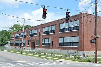 Russell School


References
- ^ a b Northside Neighborhood Profile city-data.com. Retrieved on 2011-01-01
This article needs additional citations for
verification. (May 2011) |
Northside | |
|---|---|
|
A residential neighborhood in Lexington's Northside | |
| Country | United States |
| State | Kentucky |
| County | Fayette |
| City | Lexington |
| Area | |
| • Total | 0.572 sq mi (1.48 km2) |
| Population (
2000) | |
| • Total | 3,875 |
| • Density | 6,774/sq mi (2,618.2/km2) |
| Time zone | UTC-5 ( Eastern (EST)) |
| • Summer ( DST) | UTC-4 (EDT) |
| ZIP code | 40507, 40508 |
| Area code | 859 |
Northside is a neighborhood in northern Lexington, Kentucky, United States. Its boundaries are Loudon Avenue to the north and east, Short Street, Midland Avenue, and Winchester Road to the south, and Newtown Pike to the west. [1]
Neighborhood statistics
- Population in 2000: 3,875
- Land area: 0.572 square miles (1.48 km2)
- Population density: 6,774 people per square mile (2,615 people/km2)
- Median household income: $26,159 [1]
Gallery
Numerous buildings and corridors in Lexington's Northside neighborhood are on the National Register of Historic Places, including:
-
Matthew Kennedy House
-
McCracken-Wilgus House
-
Russell School
References
- ^ a b Northside Neighborhood Profile city-data.com. Retrieved on 2011-01-01
| Subject areas |     | ||||||||
|---|---|---|---|---|---|---|---|---|---|
| Culture and landmarks |
| ||||||||
| Colleges and universities | |||||||||
| Transportation | |||||||||
| Sports | |||||||||
| Metro Lexington | |||||||||
| Neighborhoods |
| ||||||||