 | ||||
| Route information | ||||
| Maintained by NCDOT | ||||
| Length | 18.8 mi [1] (30.3 km) | |||
| Existed | 1930–present | |||
| Major junctions | ||||
| South end | ||||
| North end | ||||
| Location | ||||
| Country | United States | |||
| State | North Carolina | |||
| Counties | Gaston | |||
| Highway system | ||||
| ||||
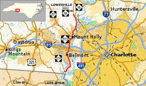
North Carolina Highway 273 (NC 273) is a primary state highway in the U.S. state of North Carolina. It connects towns and communities along the banks of the Catawba River, in eastern Gaston County.
Route description
North Carolina Highway 273 "runs 18.74 miles north from NC 279 (S New Hope Road), near Lake Wylie and the South Carolina state line, to NC 16 Business at Lucia" [2]
History
Established in 1930 as a new primary routing, from NC 29 (now NC 7), at Belmont Abbey, to NC 27, in Mount Holly. In 1940, NC 273 was extended north to NC 16, near Lucia. In 1949 or 1950, NC 273 was extended north again, along NC 16, then west on an upgraded road to NC 27, near Goodsonville. In 1967, NC 273 was moved back to its northern terminus at NC 16; the highway between NC 16 and NC 27 became part of NC 73. Between 1980 and 1982, NC 273 was extended south to its current southern terminus at NC 279. In 1988 or 1989, NC 273 was extended north to its current northern terminus in Lucia. In 2000 or 2001, NC 273 was rerouted east around downtown Mount Holly. [3]
Junction list
The entire route is in Gaston County.
| Location | mi [1] | km | Destinations | Notes | |
|---|---|---|---|---|---|
| | 0.0 | 0.0 | |||
| Belmont | 7.4 | 11.9 | |||
| 7.9 | 12.7 | ||||
| 8.2– 8.5 | 13.2– 13.7 | Exit 27 (I-85) | |||
| Mount Holly | 11.5 | 18.5 | |||
| Lucia | 18.8 | 30.3 | |||
| 1.000 mi = 1.609 km; 1.000 km = 0.621 mi | |||||
References
- ^ a b Google (February 16, 2016). "North Carolina Highway 273" (Map). Google Maps. Google. Retrieved February 16, 2016.
- ^ "Highway 273 - AARoads - North Carolina".
- ^ "NCRoads.com: N.C. 273". Retrieved 2012-01-08.[ self-published source]
