Wujiang
Üchang Noh | |
|---|---|
Village | |
 Wujiang | |
| Coordinates: 33°37′06″N 79°48′34″E / 33.6184°N 79.8095°E | |
| Country | China |
| Region | Tibet |
| Prefecture | Ngari |
| County | Rutog |
| Area | |
| • Total | 4,500 km2 (1,700 sq mi) |
| Elevation | 4,322 m (14,180 ft) |
| Population (2009)
[2] | |
| • Total | 818 |
| Wujang | |||||||
|---|---|---|---|---|---|---|---|
| Chinese | 乌 江 村 | ||||||
| Hanyu Pinyin | Wūjiāng cūn | ||||||
| Literal meaning | "Wujang Village" | ||||||
| |||||||
Noh, [3] also called Üchang or Wujang [4] ( Tibetan: དབུས་བྱང, Wylie: dbus byang, THL: wü jang) [5] is a village in the Rutog County, Ngari Prefecture of the Tibet region of China. It is located on the northern bank of the eastern Pangong Lake (Tso Ngombo), watered by the Doma River (Tsanger-schar). The village is now part of the Domar Township.
Noh is described as a temple town by European travellers. It is the only permanently inhabited place on the northern bank of the Pangong Lake. [3] It is frequently referred to in the British records of the Pangong Lake, but the British (and "foreigners" in general) were not generally allowed to visit it. [6] [7] [8]
Geography
|
| This section needs expansion. You can help by
adding to it. (January 2021) |
The state highway S520 called Banying Highway connects Noh with the Khurnak Plain and the Kongka Pass in the Chang Chenmo Valley. The latter is on the Line of Actual Control with India. S520 also connects to the National Highway G219 (Aksai Chin road) in the east.
Current status
As of 2009, there are 818 people living in the village. [2] There is also an army base of a border defence company, which is said to have the hard task of defending a long border. According to the Xizang Government, they get along well with each other. [9]
Historical maps
-
 The Pangong Lake area in a map of Ngari Khorsum by Henry Strachey, 1851
 -
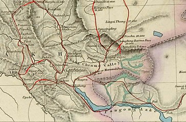 Noh along a trade route of Ladakh (1873)


-
 Map of the expeditions of Sven Hedin (1906-8) including Noh ( RGS, early 20th century)
 -
![Map including Noh (AMS, 1950)[a]](https://upload.wikimedia.org/wikipedia/commons/thumb/3/34/Txu-oclc-6654394-ni-44-3rd-ed.jpg/256px-Txu-oclc-6654394-ni-44-3rd-ed.jpg)
-
 Map showing Shan-ho ( DMA, 1980)
 -
 Map showing Wu-chiang (Wüjang) ( DMA, 1995)

![Map including Noh (AMS, 1950)[a]](/info/en/?search=File:Txu-oclc-6654394-ni-44-3rd-ed.jpg)


Notes
- ^ From map: "THE DELINEATION OF INTERNATIONAL BOUNDARIES ON THIS MAP MUST NOT BE CONSIDERED AUTHORITATIVE."
References
- ^ Hedin, Central Asia, Vol. IV (1907), p. 266.
- ^ a b 乌江村 at baidu.com
- ^ a b Hedin, Central Asia, Vol. IV (1907), pp. 267–268: "On the left bank of the river, and between it and the big bluff, stands the village of Noh, called also Odschong, the first permanently inhabited place, as it was also the last, that we encountered in Tibet."
- ^ Howard, Neil; Howard, Kath (2014), "Historic Ruins in the Gya Valley, Eastern Ladakh, and a Consideration of Their Relationship to the History of Ladakh and Maryul", in Erberto Lo Bue; John Bray (eds.), Art and Architecture in Ladakh: Cross-cultural Transmissions in the Himalayas and Karakoram, p. 97, ISBN 9789004271807: "One [possibility] is the existence (in modern times at least) of a place called Üchang (dBus byang, Chinese Wujiang) at the eastern end of the Panggong Tsho, missed by Vitali.
- ^ Tibet Autonomous Region (China): Ngari Prefecture, KNAB Place Name Databse, retrieved 27 July 2021.
- ^ Strachey, Physical Geography of Western Tibet (1854), p. 46: "there are also said to be wide plains open to the [Pangong] lake in the southern horn [of the lake], at Ruduk in the [south], and at No [Noh] on the [north] side, but these formed in whole or part by the mouths of the lateral valleys opening into the immediate basin of the lake."
- ^ Godwin-Austen, Pangong Lake District (1867), pp. 354–355: "Near the northern shore of this last [lake] is situated the small village of Noh, a short distance up a tributary from the north.... The Champas or Changpas, who spend the winter on the lake at Ote [i.e., the Khurnak Plain], come from both Noh and Rudok."
- ^ Gazetteer of Kashmir and Ladak (1890), pp. 638, 650
- ^ "日土县多玛乡乌江村 多举措加深军民鱼水情_西藏自治区人民政府".
Bibliography
- Gazetteer of Kashmir and Ladak, Calcutta: Superintendent of Government Printing, 1890
- Godwin-Austen, H. H. (1867). "Notes on the Pangong Lake District of Ladakh, from a Journal Made during a Survey in 1863". Journal of the Royal Geographical Society of London. 37: 343–363. doi: 10.2307/1798534. JSTOR 1798534.
- Hedin, Sven (1907), Scientific Results of a Journey in Central Asia, 1899–1902, Vol. IV: Central and West Tibet, Stockholm: Lithographic Institute of the General Staff of the Swedish Army – via archive.org
- Strachey, Henry (1854), Physical Geography of Western Tibet, London: William Clows and Sons – via archive.org
Wujiang
Üchang Noh | |
|---|---|
Village | |
Wujiang | |
| Coordinates: 33°37′06″N 79°48′34″E / 33.6184°N 79.8095°E | |
| Country | China |
| Region | Tibet |
| Prefecture | Ngari |
| County | Rutog |
| Area | |
| • Total | 4,500 km2 (1,700 sq mi) |
| Elevation | 4,322 m (14,180 ft) |
| Population (2009)
[2] | |
| • Total | 818 |
| Wujang | |||||||
|---|---|---|---|---|---|---|---|
| Chinese | 乌 江 村 | ||||||
| Hanyu Pinyin | Wūjiāng cūn | ||||||
| Literal meaning | "Wujang Village" | ||||||
| |||||||
Noh, [3] also called Üchang or Wujang [4] ( Tibetan: དབུས་བྱང, Wylie: dbus byang, THL: wü jang) [5] is a village in the Rutog County, Ngari Prefecture of the Tibet region of China. It is located on the northern bank of the eastern Pangong Lake (Tso Ngombo), watered by the Doma River (Tsanger-schar). The village is now part of the Domar Township.
Noh is described as a temple town by European travellers. It is the only permanently inhabited place on the northern bank of the Pangong Lake. [3] It is frequently referred to in the British records of the Pangong Lake, but the British (and "foreigners" in general) were not generally allowed to visit it. [6] [7] [8]
Geography
|
| This section needs expansion. You can help by
adding to it. (January 2021) |
The state highway S520 called Banying Highway connects Noh with the Khurnak Plain and the Kongka Pass in the Chang Chenmo Valley. The latter is on the Line of Actual Control with India. S520 also connects to the National Highway G219 (Aksai Chin road) in the east.
Current status
As of 2009, there are 818 people living in the village. [2] There is also an army base of a border defence company, which is said to have the hard task of defending a long border. According to the Xizang Government, they get along well with each other. [9]
Historical maps
-
The Pangong Lake area in a map of Ngari Khorsum by Henry Strachey, 1851
-
Noh along a trade route of Ladakh (1873)
-
Map of the expeditions of Sven Hedin (1906-8) including Noh ( RGS, early 20th century)
-
-
Map showing Shan-ho ( DMA, 1980)
-
Map showing Wu-chiang (Wüjang) ( DMA, 1995)
Notes
- ^ From map: "THE DELINEATION OF INTERNATIONAL BOUNDARIES ON THIS MAP MUST NOT BE CONSIDERED AUTHORITATIVE."
References
- ^ Hedin, Central Asia, Vol. IV (1907), p. 266.
- ^ a b 乌江村 at baidu.com
- ^ a b Hedin, Central Asia, Vol. IV (1907), pp. 267–268: "On the left bank of the river, and between it and the big bluff, stands the village of Noh, called also Odschong, the first permanently inhabited place, as it was also the last, that we encountered in Tibet."
- ^ Howard, Neil; Howard, Kath (2014), "Historic Ruins in the Gya Valley, Eastern Ladakh, and a Consideration of Their Relationship to the History of Ladakh and Maryul", in Erberto Lo Bue; John Bray (eds.), Art and Architecture in Ladakh: Cross-cultural Transmissions in the Himalayas and Karakoram, p. 97, ISBN 9789004271807: "One [possibility] is the existence (in modern times at least) of a place called Üchang (dBus byang, Chinese Wujiang) at the eastern end of the Panggong Tsho, missed by Vitali.
- ^ Tibet Autonomous Region (China): Ngari Prefecture, KNAB Place Name Databse, retrieved 27 July 2021.
- ^ Strachey, Physical Geography of Western Tibet (1854), p. 46: "there are also said to be wide plains open to the [Pangong] lake in the southern horn [of the lake], at Ruduk in the [south], and at No [Noh] on the [north] side, but these formed in whole or part by the mouths of the lateral valleys opening into the immediate basin of the lake."
- ^ Godwin-Austen, Pangong Lake District (1867), pp. 354–355: "Near the northern shore of this last [lake] is situated the small village of Noh, a short distance up a tributary from the north.... The Champas or Changpas, who spend the winter on the lake at Ote [i.e., the Khurnak Plain], come from both Noh and Rudok."
- ^ Gazetteer of Kashmir and Ladak (1890), pp. 638, 650
- ^ "日土县多玛乡乌江村 多举措加深军民鱼水情_西藏自治区人民政府".
Bibliography
- Gazetteer of Kashmir and Ladak, Calcutta: Superintendent of Government Printing, 1890
- Godwin-Austen, H. H. (1867). "Notes on the Pangong Lake District of Ladakh, from a Journal Made during a Survey in 1863". Journal of the Royal Geographical Society of London. 37: 343–363. doi: 10.2307/1798534. JSTOR 1798534.
- Hedin, Sven (1907), Scientific Results of a Journey in Central Asia, 1899–1902, Vol. IV: Central and West Tibet, Stockholm: Lithographic Institute of the General Staff of the Swedish Army – via archive.org
- Strachey, Henry (1854), Physical Geography of Western Tibet, London: William Clows and Sons – via archive.org