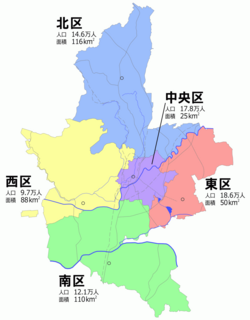

Nishi-ku (西区) is one of the five wards of Kumamoto City, Japan. Meaning literally "west ward," it is bordered by the Kita-ku, Chūō-ku, Minami-ku and also by the city of Tamana and the town of Gyokutō. As of 2012, it has a population of 93,394 people and an area of 88.21 km2.
External links
![]() Media related to
Nishi-ku, Kumamoto at Wikimedia Commons
Media related to
Nishi-ku, Kumamoto at Wikimedia Commons
32°46′35″N 130°38′51″E / 32.77639°N 130.64750°E