This article needs additional citations for
verification. (April 2022) |
Nižná Polianka | |
|---|---|
Municipality | |
 Nižná Polianka from the route to border with Poland | |
 Nižná Polianka Location of Nižná Polianka in the
Prešov Region  Nižná Polianka Location of Nižná Polianka in Slovakia | |
| Coordinates: 49°24′N 21°24′E / 49.400°N 21.400°E | |
| Country | |
| Region | Prešov |
| District | Bardejov |
| First mentioned | 1435 |
| Area | |
| • Total | 5.87 [2] km2 (2.27 [2] sq mi) |
| Elevation | 385 [3] m (1,263 [3] ft) |
| Population (
2021) | |
| • Total | 227 [1] |
| Time zone | UTC+1 ( CET) |
| • Summer ( DST) | UTC+2 ( CEST) |
| Postal code | 086 36
[3] |
| Area code | +421 54 [3] |
| Car plate | BJ |
| Website |
www |
Nižná Polianka ( Rusyn: Нижня Полянка; Hungarian: Alsópagony) is a village and municipality in Bardejov District in the Prešov Region of north-east Slovakia.
History
In historical records the village was first mentioned in 1435
Geography
The municipality lies at an altitude of 395 metres and covers an area of 5.876 km2. It has a population of about 252 people.
Media (foto, audio, documents)
-
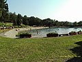 swimming pool
 -
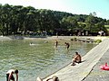 swimming pool
 -
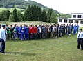 hasičská súťaž
 -
 hasičská súťaž
 -
 hasičská súťaž


References
- ^ "Počet obyvateľov podľa pohlavia - obce (ročne)". www.statistics.sk (in Slovak). Statistical Office of the Slovak Republic. 2022-03-31. Retrieved 2022-03-31.
- ^ a b "Hustota obyvateľstva - obce [om7014rr_ukaz: Rozloha (Štvorcový meter)]". www.statistics.sk (in Slovak). Statistical Office of the Slovak Republic. 2022-03-31. Retrieved 2022-03-31.
- ^ a b c d "Základná charakteristika". www.statistics.sk (in Slovak). Statistical Office of the Slovak Republic. 2015-04-17. Retrieved 2022-03-31.
- ^ a b "Hustota obyvateľstva - obce". www.statistics.sk (in Slovak). Statistical Office of the Slovak Republic. 2022-03-31. Retrieved 2022-03-31.
External links
-
 Media related to
Nižná Polianka at Wikimedia Commons
Media related to
Nižná Polianka at Wikimedia Commons -
Official website

- https://web.archive.org/web/20070513023228/http://www.statistics.sk/mosmis/eng/run.html
- sk:Nižná Polianka
|
| This Prešov Region geography article is a stub. You can help Wikipedia by expanding it. |
This article needs additional citations for
verification. (April 2022) |
Nižná Polianka | |
|---|---|
Municipality | |
|
Nižná Polianka from the route to border with Poland | |
Nižná Polianka Location of Nižná Polianka in the
Prešov Region Nižná Polianka Location of Nižná Polianka in Slovakia | |
| Coordinates: 49°24′N 21°24′E / 49.400°N 21.400°E | |
| Country | |
| Region | Prešov |
| District | Bardejov |
| First mentioned | 1435 |
| Area | |
| • Total | 5.87 [2] km2 (2.27 [2] sq mi) |
| Elevation | 385 [3] m (1,263 [3] ft) |
| Population (
2021) | |
| • Total | 227 [1] |
| Time zone | UTC+1 ( CET) |
| • Summer ( DST) | UTC+2 ( CEST) |
| Postal code | 086 36
[3] |
| Area code | +421 54 [3] |
| Car plate | BJ |
| Website |
www |
Nižná Polianka ( Rusyn: Нижня Полянка; Hungarian: Alsópagony) is a village and municipality in Bardejov District in the Prešov Region of north-east Slovakia.
History
In historical records the village was first mentioned in 1435
Geography
The municipality lies at an altitude of 395 metres and covers an area of 5.876 km2. It has a population of about 252 people.
Media (foto, audio, documents)
-
swimming pool
-
swimming pool
-
hasičská súťaž
-
hasičská súťaž
-
hasičská súťaž
References
- ^ "Počet obyvateľov podľa pohlavia - obce (ročne)". www.statistics.sk (in Slovak). Statistical Office of the Slovak Republic. 2022-03-31. Retrieved 2022-03-31.
- ^ a b "Hustota obyvateľstva - obce [om7014rr_ukaz: Rozloha (Štvorcový meter)]". www.statistics.sk (in Slovak). Statistical Office of the Slovak Republic. 2022-03-31. Retrieved 2022-03-31.
- ^ a b c d "Základná charakteristika". www.statistics.sk (in Slovak). Statistical Office of the Slovak Republic. 2015-04-17. Retrieved 2022-03-31.
- ^ a b "Hustota obyvateľstva - obce". www.statistics.sk (in Slovak). Statistical Office of the Slovak Republic. 2022-03-31. Retrieved 2022-03-31.
External links
-
Media related to
Nižná Polianka at Wikimedia Commons
-
Official website
- https://web.archive.org/web/20070513023228/http://www.statistics.sk/mosmis/eng/run.html
- sk:Nižná Polianka
|
| This Prešov Region geography article is a stub. You can help Wikipedia by expanding it. |