Ngagane | |
|---|---|
| Coordinates: 27°50′24″S 29°59′31″E / 27.840°S 29.992°E | |
| Country | South Africa |
| Province | KwaZulu-Natal |
| District | Amajuba |
| Municipality | Newcastle |
| Area | |
| • Total | 0.74 km2 (0.29 sq mi) |
| Population (2011)
[1] | |
| • Total | 906 |
| • Density | 1,200/km2 (3,200/sq mi) |
| Racial makeup (2011) | |
| • Black African | 87.6% |
| • Coloured | 0.2% |
| • White | 12.1% |
| First languages (2011) | |
| • Zulu | 83.9% |
| • Afrikaans | 8.1% |
| • English | 5.8% |
| • Other | 2.2% |
| Time zone | UTC+2 ( SAST) |
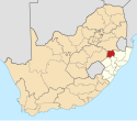
Ngagane is a town in Amajuba District Municipality in the KwaZulu-Natal province of South Africa.
Town some 11 km north of Alcockspruit and 35 km south-west of Utrecht. Of Zulu origin, the name is variously said to mean ‘the unexpected one’, referring to the way the river may suddenly come down in flood; ‘thorn-tree river’, referring to Dichrostachys or Acacia trees growing along the banks, or ‘skeleton river’, the reference being uncertain. [2]
References
- ^ a b c d "Main Place Ngagane". Census 2011.
- ^ "Dictionary of Southern African Place Names (Public Domain)". Human Science Research Council. p. 334.


