Nowy Port | |
|---|---|
District of
Gdańsk | |
 Aerial view of Nowy Port | |
 Location of Nowy Port within Gdańsk | |
| Coordinates: 54°23′51″N 18°39′54″E / 54.397627°N 18.664891°E | |
| Country | |
| Voivodeship | Pomeranian |
| County/City | Gdańsk |
| Area | |
| • Total | 2.08 km2 (0.80 sq mi) |
| Population (2019
[1]) | |
| • Total | 9,334 |
| • Density | 4,500/km2 (12,000/sq mi) |
| Time zone | UTC+1 ( CET) |
| • Summer ( DST) | UTC+2 ( CEST) |
| Vehicle registration | GD |
Nowy Port ( German: Neufahrwasser; Kashubian: Fôrwôter) is a district of the city of Gdańsk, Poland. It borders with Brzeźno to the west, Letnica to the south, and Przeróbka to the east (over the Martwa Wisła).
The landmark of the district is the historic Nowy Port Lighthouse, which is open to visitors.
During World War II, in 1939 and 1940, the district was one of places of imprisonment and executions of Polish railway workers by Nazi Germany. [2]
Population
With 10684 inhabitants and area of 2.28 km2, its population density was 4689/km2, as of 2011. [3] By 2019 the population fell to 9334, giving a population density of 4500/km². [1]
Gallery
-
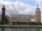 Port office and lighthouse
 -
 Port office and mouth of the Martwa Wisła river
 -
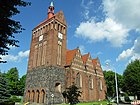 Franciscan Church of the Immaculate Heart of Mary
 -
 Polish Border Guard Unit


Sport
Portowiec Gdańsk is the local sports club.
References
- ^ a b "Podział administracyjny Gdańska". BIP - Urząd Miejski W Gdańsku (in Polish). Retrieved 5 September 2020.
- ^ Maria Wardzyńska, Był rok 1939. Operacja niemieckiej policji bezpieczeństwa w Polsce. Intelligenzaktion, IPN, Warszawa, 2009, p. 85 (in Polish)
- ^ Administrative division of Gdańsk (polish). Retrieved 15 January 2014
External links
|
| This Pomeranian Voivodeship location article is a stub. You can help Wikipedia by expanding it. |
Nowy Port | |
|---|---|
District of
Gdańsk | |
|
Aerial view of Nowy Port | |
|
Location of Nowy Port within Gdańsk | |
| Coordinates: 54°23′51″N 18°39′54″E / 54.397627°N 18.664891°E | |
| Country | |
| Voivodeship | Pomeranian |
| County/City | Gdańsk |
| Area | |
| • Total | 2.08 km2 (0.80 sq mi) |
| Population (2019
[1]) | |
| • Total | 9,334 |
| • Density | 4,500/km2 (12,000/sq mi) |
| Time zone | UTC+1 ( CET) |
| • Summer ( DST) | UTC+2 ( CEST) |
| Vehicle registration | GD |
Nowy Port ( German: Neufahrwasser; Kashubian: Fôrwôter) is a district of the city of Gdańsk, Poland. It borders with Brzeźno to the west, Letnica to the south, and Przeróbka to the east (over the Martwa Wisła).
The landmark of the district is the historic Nowy Port Lighthouse, which is open to visitors.
During World War II, in 1939 and 1940, the district was one of places of imprisonment and executions of Polish railway workers by Nazi Germany. [2]
Population
With 10684 inhabitants and area of 2.28 km2, its population density was 4689/km2, as of 2011. [3] By 2019 the population fell to 9334, giving a population density of 4500/km². [1]
Gallery
-
Port office and lighthouse
-
Port office and mouth of the Martwa Wisła river
-
Franciscan Church of the Immaculate Heart of Mary
-
Polish Border Guard Unit
Sport
Portowiec Gdańsk is the local sports club.
References
- ^ a b "Podział administracyjny Gdańska". BIP - Urząd Miejski W Gdańsku (in Polish). Retrieved 5 September 2020.
- ^ Maria Wardzyńska, Był rok 1939. Operacja niemieckiej policji bezpieczeństwa w Polsce. Intelligenzaktion, IPN, Warszawa, 2009, p. 85 (in Polish)
- ^ Administrative division of Gdańsk (polish). Retrieved 15 January 2014
External links
Gdańsk articles | |||||||
|---|---|---|---|---|---|---|---|
| History of Gdańsk |
| ||||||
| Politics |
| ||||||
| Districts |
| ||||||
| Landmarks |
| ||||||
| Culture and events |
| ||||||
| Universities and academies | |||||||
|
| This Pomeranian Voivodeship location article is a stub. You can help Wikipedia by expanding it. |