Photos • Location
You can help expand this article with text translated from
the corresponding article in Lithuanian. (October 2011) Click [show] for important translation instructions.
|
| Nereta | |
|---|---|
 | |
| Location | |
| Countries | Lithuania, Latvia |
| Region | Biržai district municipality, Panevėžys County, Nereta Municipality |
| Physical characteristics | |
| Source | |
| • location | Sargūni swamp |
| Mouth | Nemunėlis |
• coordinates | 56°11′07″N 25°05′34″E / 56.18519°N 25.09271°E |
• elevation | 69.2 m (227 ft) |
| Length | 25 km (16 mi) |
| Basin size | 108 km² |
| Basin features | |
| Progression | Nemunėlis→ Lielupe→ Baltic Sea |
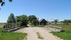
Nereta ( Latvian: Neretiņa) is a river of Biržai district municipality, Panevėžys County, northern Lithuania and Southern Latvia. It flows for 25 kilometres (16 mi). For 18 km (11 mi), the river forms the border between Latvia and Lithuania. It is a right tributary of the Nemunėlis. [1]
References
You can help expand this article with text translated from
the corresponding article in Lithuanian. (October 2011) Click [show] for important translation instructions.
|
| Nereta | |
|---|---|
 | |
| Location | |
| Countries | Lithuania, Latvia |
| Region | Biržai district municipality, Panevėžys County, Nereta Municipality |
| Physical characteristics | |
| Source | |
| • location | Sargūni swamp |
| Mouth | Nemunėlis |
• coordinates | 56°11′07″N 25°05′34″E / 56.18519°N 25.09271°E |
• elevation | 69.2 m (227 ft) |
| Length | 25 km (16 mi) |
| Basin size | 108 km² |
| Basin features | |
| Progression | Nemunėlis→ Lielupe→ Baltic Sea |
Nereta ( Latvian: Neretiņa) is a river of Biržai district municipality, Panevėžys County, northern Lithuania and Southern Latvia. It flows for 25 kilometres (16 mi). For 18 km (11 mi), the river forms the border between Latvia and Lithuania. It is a right tributary of the Nemunėlis. [1]
References