Nazareth Historic District | |
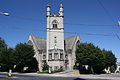
 Center Square. Nazareth Moravian Church. August 2013. | |
  | |
| Location | Centered on Center and Main Sts., Nazareth, Pennsylvania |
|---|---|
| Coordinates | 40°44′31″N 75°18′39″W / 40.74194°N 75.31083°W |
| Area | 188 acres (76 ha) |
| Built | 1858 |
| Architectural style | Late 19th And 20th Century Revivals, Late Victorian, Moravian |
| NRHP reference No. | 88001203 [1] |
| Added to NRHP | August 11, 1988 |
The Nazareth Historic District is a national historic district located in the center of the Borough of Nazareth, Northampton County, Pennsylvania, which is located ten miles northeast of Bethlehem and seven miles northwest of Easton. [2] [3]
It was added to the National Register of Historic Places in 1988. [1]
History
Mostly residential in nature, with commercial buildings located in its central section, the Nazareth Historic District was laid out in a grid pattern between the mid-eighteenth and early twentieth centuries, and includes 503 contributing buildings and 1 contributing site (Moravian Congregational Cemetery). The buildings are primarily 2 1/2 stories tall and constructed of brick or frame. Most of the remaining stone buildings were built prior to 1858 when Nazareth came under civil control from the Moravian church. [4]
Notable non-residential buildings include the Nazareth Moravian Church (1861, St. John's U.C.C. Church (1905-1907), and St. John's Lutheran Church (1858). Located in the district is the separately listed Nazareth Hall Tract. [4]
It was added to the National Register of Historic Places in 1988. [1]
Gallery
-
 Nazareth Moravian Church
 -
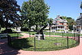 Civil War Monument on Center Square
 -
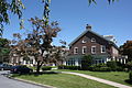 Memorial Library of Nazareth
 -
 Belvidere Street.
 -
 St. John's United Church of Christ (1906)


References
- ^ a b c "National Register Information System". National Register of Historic Places. National Park Service. July 9, 2010.
- ^ " History." Nazareth, Pennsylvania: Borough of Nazareth, retrieved online July 9, 2019.
- ^ Novak, Steve. "Lehigh Valley history, A to Z: Every site on the National Register of Historic Places." Allentown, Pennsylvania: Lehigh Valley Live, March 2018.
- ^ a b "National Historic Landmarks & National Register of Historic Places in Pennsylvania" (Searchable database). CRGIS: Cultural Resources Geographic Information System. Note: This includes Evelyn Huth, Lance E. Metz and Angelo Spinosa / William Sisson (1988). "National Register of Historic Places Inventory Nomination Form: Nazareth Historic District" (PDF). Retrieved October 29, 2011.

Nazareth Historic District | |
|
Center Square. Nazareth Moravian Church. August 2013. | |
| |
| Location | Centered on Center and Main Sts., Nazareth, Pennsylvania |
|---|---|
| Coordinates | 40°44′31″N 75°18′39″W / 40.74194°N 75.31083°W |
| Area | 188 acres (76 ha) |
| Built | 1858 |
| Architectural style | Late 19th And 20th Century Revivals, Late Victorian, Moravian |
| NRHP reference No. | 88001203 [1] |
| Added to NRHP | August 11, 1988 |
The Nazareth Historic District is a national historic district located in the center of the Borough of Nazareth, Northampton County, Pennsylvania, which is located ten miles northeast of Bethlehem and seven miles northwest of Easton. [2] [3]
It was added to the National Register of Historic Places in 1988. [1]
History
Mostly residential in nature, with commercial buildings located in its central section, the Nazareth Historic District was laid out in a grid pattern between the mid-eighteenth and early twentieth centuries, and includes 503 contributing buildings and 1 contributing site (Moravian Congregational Cemetery). The buildings are primarily 2 1/2 stories tall and constructed of brick or frame. Most of the remaining stone buildings were built prior to 1858 when Nazareth came under civil control from the Moravian church. [4]
Notable non-residential buildings include the Nazareth Moravian Church (1861, St. John's U.C.C. Church (1905-1907), and St. John's Lutheran Church (1858). Located in the district is the separately listed Nazareth Hall Tract. [4]
It was added to the National Register of Historic Places in 1988. [1]
Gallery
-
Nazareth Moravian Church
-
Civil War Monument on Center Square
-
Memorial Library of Nazareth
-
Belvidere Street.
-
St. John's United Church of Christ (1906)
References
- ^ a b c "National Register Information System". National Register of Historic Places. National Park Service. July 9, 2010.
- ^ " History." Nazareth, Pennsylvania: Borough of Nazareth, retrieved online July 9, 2019.
- ^ Novak, Steve. "Lehigh Valley history, A to Z: Every site on the National Register of Historic Places." Allentown, Pennsylvania: Lehigh Valley Live, March 2018.
- ^ a b "National Historic Landmarks & National Register of Historic Places in Pennsylvania" (Searchable database). CRGIS: Cultural Resources Geographic Information System. Note: This includes Evelyn Huth, Lance E. Metz and Angelo Spinosa / William Sisson (1988). "National Register of Historic Places Inventory Nomination Form: Nazareth Historic District" (PDF). Retrieved October 29, 2011.