Photos • Location
| Naruse River 鳴瀬川 | |
|---|---|
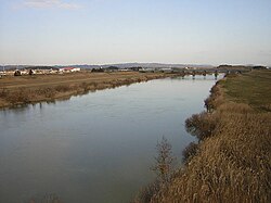
 Naruse River in 2007 | |
| Location | |
| Country | Japan |
| State | Honshu |
| Region | Miyagi |
| District | Ōsaki |
| Physical characteristics | |
| Source | Mount Funagata |
| • elevation | 1,500 m (4,900 ft) |
| Mouth | Ishinomaki Bay |
• coordinates | 38°22′34″N 141°10′29″E / 38.3762°N 141.1747°E |
| Length | 89 km (55 mi) |
| Basin size | 1,133 km2 (437 sq mi) |
Naruse River (鳴瀬川) is a river in Miyagi Prefecture, Japan. [1]
References
| Naruse River 鳴瀬川 | |
|---|---|
 Naruse River in 2007 | |
| Location | |
| Country | Japan |
| State | Honshu |
| Region | Miyagi |
| District | Ōsaki |
| Physical characteristics | |
| Source | Mount Funagata |
| • elevation | 1,500 m (4,900 ft) |
| Mouth | Ishinomaki Bay |
• coordinates | 38°22′34″N 141°10′29″E / 38.3762°N 141.1747°E |
| Length | 89 km (55 mi) |
| Basin size | 1,133 km2 (437 sq mi) |
Naruse River (鳴瀬川) is a river in Miyagi Prefecture, Japan. [1]
References