| Naamans Creek | |
|---|---|
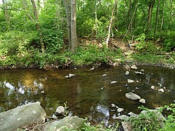
 Naamans Creek at Woods Haven Kruse Park | |
| Location | |
| Country | United States |
| State | Delaware |
| State | Pennsylvania |
| County | New Castle, Delaware |
| County | Delaware, Pennsylvania |
| Physical characteristics | |
| Source | confluence of West Branch and East Branch Naamans Creek |
| • location | Bethel Township, Pennsylvania |
| • coordinates | 39°50′34″N 75°29′32″W / 39.84278°N 75.49222°W [1] |
| Mouth | Delaware River |
• location | Claymont, Delaware |
• coordinates | 39°48′19″N 75°26′11″W / 39.80528°N 75.43639°W [1] |
• elevation | sea level (0 ft.) |
| Basin features | |
| Progression | Delaware River → Delaware Bay → Atlantic Ocean |
| River system | Delaware River |
| Tributaries | |
| • left | East Branch Naamans Creek |
| • right | West Branch Naamans Creek South Branch Naamans Creek |
Naamans Creek (spelled Naaman Creek on federal maps) [2] is a tributary of the Delaware River that is located in northeast New Castle County, Delaware and southeast Delaware County, Pennsylvania. [3]
History and geography
This creek is believed to be named after a Minqua chief who befriended the Swedish settlers of the area. [4] A large tract of land along the creek was deeded to Governor Johan Risingh by chief Peminacka in 1655. [5]
The stream rises near the intersection of Foulk Road and Naamans Creek Road at 39°50′34″N 75°29′32″W / 39.84278°N 75.49222°W in Bethel Township, Pennsylvania, flows through Arden, Delaware, [6] and discharges into the Delaware River at 39°48′19″N 75°26′11″W / 39.80528°N 75.43639°W in Claymont, Delaware. [2]
See also
References
- ^ a b "GNIS Detail - Naaman Creek". geonames.usgs.gov. Retrieved 19 May 2019.
- ^ a b U.S. Geological Survey Geographic Names Information System: Naaman Creek
- ^ "Naamans Creek Watershed" (PDF). Delaware Department of Natural Resources & Environmental Control. Retrieved April 29, 2011.
- ^ Ferris, Benjamin (1987) [1846]. A history of the original settlements on the Delaware-- & a history of Wilmington. Wilmington, DE: Gateway Press ; Book orders to Delaware Genealogical Society. p. 134. OCLC 17298839, 865874829, 1013367022.
- ^ "State of Delaware". www.delaware.gov. Archived from the original on 3 May 2009. Retrieved 22 June 2017.
- ^ Wiencek, Henry (May 1992). "Laying out the idyllic life in a latter-day Arden". Smithsonian. 23 (2). Washington, D.C: Smithsonian Institution: 124. ISSN 0037-7333. OCLC 265517591.
| Naamans Creek | |
|---|---|
 Naamans Creek at Woods Haven Kruse Park | |
| Location | |
| Country | United States |
| State | Delaware |
| State | Pennsylvania |
| County | New Castle, Delaware |
| County | Delaware, Pennsylvania |
| Physical characteristics | |
| Source | confluence of West Branch and East Branch Naamans Creek |
| • location | Bethel Township, Pennsylvania |
| • coordinates | 39°50′34″N 75°29′32″W / 39.84278°N 75.49222°W [1] |
| Mouth | Delaware River |
• location | Claymont, Delaware |
• coordinates | 39°48′19″N 75°26′11″W / 39.80528°N 75.43639°W [1] |
• elevation | sea level (0 ft.) |
| Basin features | |
| Progression | Delaware River → Delaware Bay → Atlantic Ocean |
| River system | Delaware River |
| Tributaries | |
| • left | East Branch Naamans Creek |
| • right | West Branch Naamans Creek South Branch Naamans Creek |
Naamans Creek (spelled Naaman Creek on federal maps) [2] is a tributary of the Delaware River that is located in northeast New Castle County, Delaware and southeast Delaware County, Pennsylvania. [3]
History and geography
This creek is believed to be named after a Minqua chief who befriended the Swedish settlers of the area. [4] A large tract of land along the creek was deeded to Governor Johan Risingh by chief Peminacka in 1655. [5]
The stream rises near the intersection of Foulk Road and Naamans Creek Road at 39°50′34″N 75°29′32″W / 39.84278°N 75.49222°W in Bethel Township, Pennsylvania, flows through Arden, Delaware, [6] and discharges into the Delaware River at 39°48′19″N 75°26′11″W / 39.80528°N 75.43639°W in Claymont, Delaware. [2]
See also
References
- ^ a b "GNIS Detail - Naaman Creek". geonames.usgs.gov. Retrieved 19 May 2019.
- ^ a b U.S. Geological Survey Geographic Names Information System: Naaman Creek
- ^ "Naamans Creek Watershed" (PDF). Delaware Department of Natural Resources & Environmental Control. Retrieved April 29, 2011.
- ^ Ferris, Benjamin (1987) [1846]. A history of the original settlements on the Delaware-- & a history of Wilmington. Wilmington, DE: Gateway Press ; Book orders to Delaware Genealogical Society. p. 134. OCLC 17298839, 865874829, 1013367022.
- ^ "State of Delaware". www.delaware.gov. Archived from the original on 3 May 2009. Retrieved 22 June 2017.
- ^ Wiencek, Henry (May 1992). "Laying out the idyllic life in a latter-day Arden". Smithsonian. 23 (2). Washington, D.C: Smithsonian Institution: 124. ISSN 0037-7333. OCLC 265517591.

