Photos • Location
Nátaga | |
|---|---|
Municipality and town | |
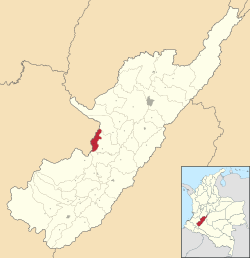
 Location of the municipality and town of Nataga in the Huila Department of Colombia. | |
| Country | |
| Department | Huila Department |
| Time zone | UTC-5 (Colombia Standard Time) |
| Website | http://www.nataga-huila.gov.co/ |
Nátaga (Spanish pronunciation: [ˈnataɣa]) is a town and municipality in the Huila Department, Colombia.
Nátaga | |
|---|---|
Municipality and town | |
 Location of the municipality and town of Nataga in the Huila Department of Colombia. | |
| Country | |
| Department | Huila Department |
| Time zone | UTC-5 (Colombia Standard Time) |
| Website | http://www.nataga-huila.gov.co/ |
Nátaga (Spanish pronunciation: [ˈnataɣa]) is a town and municipality in the Huila Department, Colombia.

