| Mynydd Moel | |
|---|---|
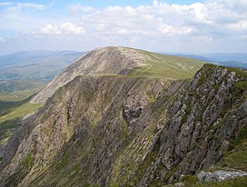
 Mynydd Moel from
Cadair Idris | |
| Highest point | |
| Elevation | 863 m (2,831 ft) |
| Prominence | 67 m (220 ft) |
| Parent peak | Cadair Idris |
| Listing | Hewitt, Nuttall |
| Naming | |
| English translation | Bare Mountain |
| Language of name | Welsh |
| Geography | |
| Location | Gwynedd, Wales |
| Parent range | Cadair Idris |
| OS grid | SH711130 |
| Topo map | OS Landranger 124, Explorer OL23 |
| Climbing | |
| Easiest route | Hike |
Mynydd Moel is the second highest summit of Cadair Idris in the Snowdonia National Park, in Gwynedd, northwest Wales.

It lies to the east of Cadair Idris and is often climbed as a horseshoe along with Craig Cwm Amarch and Cadair Idris.
The summit is bare and rocky and marked with a cairn. The north face like Cadair Idris has large cliffs. To the east is a lower broad plateau topped by the summit of Gau Graig. [1]
- ^ Nuttall, John & Anne (1999). The Mountains of England & Wales - Volume 1: Wales (2nd edition ed.). Milnthorpe, Cumbria: Cicerone. ISBN 1-85284-304-7.
| Mynydd Moel | |
|---|---|
 Mynydd Moel from
Cadair Idris | |
| Highest point | |
| Elevation | 863 m (2,831 ft) |
| Prominence | 67 m (220 ft) |
| Parent peak | Cadair Idris |
| Listing | Hewitt, Nuttall |
| Naming | |
| English translation | Bare Mountain |
| Language of name | Welsh |
| Geography | |
| Location | Gwynedd, Wales |
| Parent range | Cadair Idris |
| OS grid | SH711130 |
| Topo map | OS Landranger 124, Explorer OL23 |
| Climbing | |
| Easiest route | Hike |
Mynydd Moel is the second highest summit of Cadair Idris in the Snowdonia National Park, in Gwynedd, northwest Wales.

It lies to the east of Cadair Idris and is often climbed as a horseshoe along with Craig Cwm Amarch and Cadair Idris.
The summit is bare and rocky and marked with a cairn. The north face like Cadair Idris has large cliffs. To the east is a lower broad plateau topped by the summit of Gau Graig. [1]
- ^ Nuttall, John & Anne (1999). The Mountains of England & Wales - Volume 1: Wales (2nd edition ed.). Milnthorpe, Cumbria: Cicerone. ISBN 1-85284-304-7.