Photos • Location
| Musgrave Yarraden, Queensland | |
|---|---|
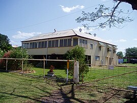
 Former Musgrave Telegraph Station, now Musgrave Roadhouse, 2003 | |
| Coordinates | 14°46′51″S 143°30′13″E / 14.78077°S 143.50372°E |
| Postcode(s) | 4892 |
| LGA(s) | Shire of Cook |
Musgrave is a neighbourhood in Queensland, Australia. It is within the locality of Yarraden in the local government area of the Shire of Cook. It bordered on the tribal lands of the Yetteneru to the east.
Musgrave has a number of heritage-listed sites, including:
- Peninsula Development Road: Musgrave Telegraph Station [1]
- ^ "Musgrave Telegraph Station (former) (entry 600431)". Queensland Heritage Register. Queensland Heritage Council. Retrieved 7 July 2013.
![]() Media related to
Musgrave, Queensland at Wikimedia Commons
Media related to
Musgrave, Queensland at Wikimedia Commons
| Musgrave Yarraden, Queensland | |
|---|---|
 Former Musgrave Telegraph Station, now Musgrave Roadhouse, 2003 | |
| Coordinates | 14°46′51″S 143°30′13″E / 14.78077°S 143.50372°E |
| Postcode(s) | 4892 |
| LGA(s) | Shire of Cook |
Musgrave is a neighbourhood in Queensland, Australia. It is within the locality of Yarraden in the local government area of the Shire of Cook. It bordered on the tribal lands of the Yetteneru to the east.
Musgrave has a number of heritage-listed sites, including:
- Peninsula Development Road: Musgrave Telegraph Station [1]
- ^ "Musgrave Telegraph Station (former) (entry 600431)". Queensland Heritage Register. Queensland Heritage Council. Retrieved 7 July 2013.
![]() Media related to
Musgrave, Queensland at Wikimedia Commons
Media related to
Musgrave, Queensland at Wikimedia Commons
