Photos • Location
Map of Manihiki Atoll


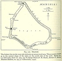
Murihiti is one of 43 islands in the Manihiki atoll of the Cook Islands. [1] It is a small island, in the gap in the atoll between Tauhunu and Ngake.
References
- ^ Te Rangi Hiroa (1932). Ethnology of Manihiki and Rakahanga. Honolulu: Bernice P. Bishop Museum. p. 6. Retrieved 13 August 2020.
10°23′43.69″S 161°1′30.22″W / 10.3954694°S 161.0250611°W
|
| This article about an island in the Cook Islands is a stub. You can help Wikipedia by expanding it. |