| Murg | |
|---|---|
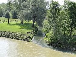
 Confluence of the Murg with the Thur | |
| Location | |
| Country | Switzerland |
| Physical characteristics | |
| Source | Canton of St. Gallen |
| Mouth | Thur |
• coordinates | 47°34′46″N 8°53′04″E / 47.5795°N 8.8845°E |
| Length | 34.1 kilometres (21.2 mi) |
| Basin features | |
| Progression | Thur→ Rhine→ North Sea |
The Murg is a 34.1 kilometres (21.2 mi) long tributary of the Thur in Switzerland. It rises in the canton of St. Gallen, flows through the canton of Thurgau, and joins the Thur near Warth.
Along its route, the river flows through the communities of Mosnang, Fischingen, Sirnach, Münchwilen, Wängi, Stettfurt, Matzingen and Frauenfeld. Between Münchwilen and Frauenfeld the river is closely followed by the Frauenfeld–Wil railway line.
External links
-
 Media related to
Murg at Wikimedia Commons
 - Hydrographic data of the Murg on the FOEN website (in German)
| Murg | |
|---|---|
 Confluence of the Murg with the Thur | |
| Location | |
| Country | Switzerland |
| Physical characteristics | |
| Source | Canton of St. Gallen |
| Mouth | Thur |
• coordinates | 47°34′46″N 8°53′04″E / 47.5795°N 8.8845°E |
| Length | 34.1 kilometres (21.2 mi) |
| Basin features | |
| Progression | Thur→ Rhine→ North Sea |
The Murg is a 34.1 kilometres (21.2 mi) long tributary of the Thur in Switzerland. It rises in the canton of St. Gallen, flows through the canton of Thurgau, and joins the Thur near Warth.
Along its route, the river flows through the communities of Mosnang, Fischingen, Sirnach, Münchwilen, Wängi, Stettfurt, Matzingen and Frauenfeld. Between Münchwilen and Frauenfeld the river is closely followed by the Frauenfeld–Wil railway line.
External links
-
 Media related to
Murg at Wikimedia Commons
 - Hydrographic data of the Murg on the FOEN website (in German)