Photos • Location
Mucurici | |
|---|---|
Municipality | |
| The Municipality of Mucurici | |
| Motto(s): "Ação e desenvolvimento" (Action and development) | |
 Location in the
State of Espírito Santo | |
| Coordinates: 18°05′34″S 40°30′57″W / 18.09278°S 40.51583°W | |
| Country | |
| Region | Southeast |
| State |
|
| Founded | December 11, 1953 |
| Government | |
| • Mayor | Atanael Passos Wagmacker ( PMDB) |
| Area | |
| • Total | 537.711 km2 (207.611 sq mi) |
| [1] | |
| Population (2020
[2]) | |
| • Total | 5,496 |
| • Density | 11.6/km2 (30/sq mi) |
| Time zone | UTC−3 ( BRT) |
| HDI (2000) | 0.679 – medium [3] |
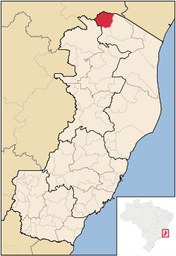
Mucurici is the northernmost municipality in the Brazilian state of Espírito Santo. Its population was 5,496 (2020) and its area is 537.711 km².
References
Mucurici | |
|---|---|
Municipality | |
| The Municipality of Mucurici | |
| Motto(s): "Ação e desenvolvimento" (Action and development) | |
 Location in the
State of Espírito Santo | |
| Coordinates: 18°05′34″S 40°30′57″W / 18.09278°S 40.51583°W | |
| Country | |
| Region | Southeast |
| State |
|
| Founded | December 11, 1953 |
| Government | |
| • Mayor | Atanael Passos Wagmacker ( PMDB) |
| Area | |
| • Total | 537.711 km2 (207.611 sq mi) |
| [1] | |
| Population (2020
[2]) | |
| • Total | 5,496 |
| • Density | 11.6/km2 (30/sq mi) |
| Time zone | UTC−3 ( BRT) |
| HDI (2000) | 0.679 – medium [3] |
Mucurici is the northernmost municipality in the Brazilian state of Espírito Santo. Its population was 5,496 (2020) and its area is 537.711 km².


