Photos • Location
| Mount Yūbari | |
|---|---|
| 夕張岳 | |
 | |
| Highest point | |
| Elevation | 1,667.7 m (5,471 ft) |
| Listing | List of mountains and hills of Japan by height |
| Coordinates | 43°5′59″N 142°15′3″E / 43.09972°N 142.25083°E |
| Geography | |
| Location | On the border of Minamifurano, Yūbari, Hokkaidō, Japan |
| Parent range | Yūbari Mountains |
| Topo map |
Geographical Survey Institute 25000:1 夕張岳 50000:1 夕張岳 |
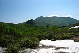
Mount Yūbari (夕張岳, Yūbari-dake) is a mountain of the Yūbari Mountains. It is located On the border of Minamifurano, Yūbari, Hokkaidō, Japan.
References
- Geographical Survey Institute
- Yubari-dake Mountain Trail, Charm of Hokkaido
| Mount Yūbari | |
|---|---|
| 夕張岳 | |
 | |
| Highest point | |
| Elevation | 1,667.7 m (5,471 ft) |
| Listing | List of mountains and hills of Japan by height |
| Coordinates | 43°5′59″N 142°15′3″E / 43.09972°N 142.25083°E |
| Geography | |
| Location | On the border of Minamifurano, Yūbari, Hokkaidō, Japan |
| Parent range | Yūbari Mountains |
| Topo map |
Geographical Survey Institute 25000:1 夕張岳 50000:1 夕張岳 |
Mount Yūbari (夕張岳, Yūbari-dake) is a mountain of the Yūbari Mountains. It is located On the border of Minamifurano, Yūbari, Hokkaidō, Japan.
References
- Geographical Survey Institute
- Yubari-dake Mountain Trail, Charm of Hokkaido