Mount Olive, Arkansas | |
|---|---|
 Mount Olive, Arkansas  Mount Olive, Arkansas | |
| Coordinates: 33°25′44″N 92°03′32″W / 33.42889°N 92.05889°W | |
| Country | United States |
| State | Arkansas |
| County | Bradley |
| Elevation | 197 ft (60 m) |
| Time zone | UTC-6 ( Central (CST)) |
| • Summer ( DST) | UTC-5 (CDT) |
| Area code | 870 |
| GNIS feature ID | 57129 [1] |
Mount Olive is an unincorporated community in Bradley County, Arkansas, United States. [1] It is the location of (or is the nearest community to) Mt. Olive Rosenwald School, which is located on Bradley Rd. 45 and is listed on the National Register of Historic Places. [2] Goepel was previously the name used for Mount Olive. [3]
In 1910, the Warren, Johnsville and Saline River Railroad opened a tap line railroad to Goepel (Mt. Olive) in 1910. The branch to Mount Olive was abandoned before 1985. [4]
Jerry Wayne Ross of Mount Olive was killed in action on 1966-09-26 in the Vietnam War. [5]
References
- ^ a b "Mount Olive". Geographic Names Information System. United States Geological Survey, United States Department of the Interior.
- ^ "National Register Information System". National Register of Historic Places. National Park Service. March 13, 2009.
- ^ [1] Dew, Lee A. “The Arkansas Tap Line Cases: A Study in Commerce Regulation.” The Arkansas Historical Quarterly, vol. 29, no. 4, 1970, pp. 327–344. JSTOR, www.jstor.org/stable/40025485. Accessed 15 Aug. 2021. A map showing the route is on Page 12 of 20. A TAP railroad line from the (Warren & Ouachita Valley railroad) at Glynn to New Edinburg, to Daughton and the (St. L. S. W. railroad)
- ^ Quoted from Warren and Saline River Railroad. See that article for references.
- ^ [2] (listed as Ingalls, Arkansas on the War Memorial in Washington, D.C.)
Municipalities and communities of
Bradley County, Arkansas, United States | ||
|---|---|---|
| Cities | 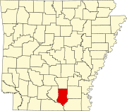 | |
| Town | ||
|
Unincorporated communities | ||
|
| This article about a location in Bradley County, Arkansas is a stub. You can help Wikipedia by expanding it. |
Mount Olive, Arkansas | |
|---|---|
Mount Olive, Arkansas Mount Olive, Arkansas | |
| Coordinates: 33°25′44″N 92°03′32″W / 33.42889°N 92.05889°W | |
| Country | United States |
| State | Arkansas |
| County | Bradley |
| Elevation | 197 ft (60 m) |
| Time zone | UTC-6 ( Central (CST)) |
| • Summer ( DST) | UTC-5 (CDT) |
| Area code | 870 |
| GNIS feature ID | 57129 [1] |
Mount Olive is an unincorporated community in Bradley County, Arkansas, United States. [1] It is the location of (or is the nearest community to) Mt. Olive Rosenwald School, which is located on Bradley Rd. 45 and is listed on the National Register of Historic Places. [2] Goepel was previously the name used for Mount Olive. [3]
In 1910, the Warren, Johnsville and Saline River Railroad opened a tap line railroad to Goepel (Mt. Olive) in 1910. The branch to Mount Olive was abandoned before 1985. [4]
Jerry Wayne Ross of Mount Olive was killed in action on 1966-09-26 in the Vietnam War. [5]
References
- ^ a b "Mount Olive". Geographic Names Information System. United States Geological Survey, United States Department of the Interior.
- ^ "National Register Information System". National Register of Historic Places. National Park Service. March 13, 2009.
- ^ [1] Dew, Lee A. “The Arkansas Tap Line Cases: A Study in Commerce Regulation.” The Arkansas Historical Quarterly, vol. 29, no. 4, 1970, pp. 327–344. JSTOR, www.jstor.org/stable/40025485. Accessed 15 Aug. 2021. A map showing the route is on Page 12 of 20. A TAP railroad line from the (Warren & Ouachita Valley railroad) at Glynn to New Edinburg, to Daughton and the (St. L. S. W. railroad)
- ^ Quoted from Warren and Saline River Railroad. See that article for references.
- ^ [2] (listed as Ingalls, Arkansas on the War Memorial in Washington, D.C.)
Municipalities and communities of
Bradley County, Arkansas, United States | ||
|---|---|---|
| Cities | | |
| Town | ||
|
Unincorporated communities | ||
|
| This article about a location in Bradley County, Arkansas is a stub. You can help Wikipedia by expanding it. |