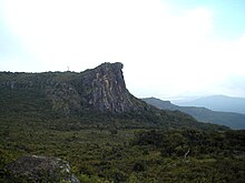
Mount Loura (Fello Loura in the
Pular language) is the northernmost point and highest peak at 1,573 metres (5,161 ft) in the
Fouta Djallon in northern
Guinea.[1] It is 7 km from the
prefecture of
Mali-ville. It is part of a complex of mountains called the
Massif de Tamgue, which rises to steep cliffs on three sides, and provides views into
Senegal and
Mali.