| Mount Cobbler | |
|---|---|
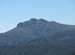
 Mount Cobbler viewed from Mount Stirling | |
| Highest point | |
| Elevation | 1,628 metres (5,341 ft) AHD [1] |
| Coordinates | 37°2′38″S 146°35′27″E / 37.04389°S 146.59083°E [2] |
| Geography | |
| Parent range | Great Dividing Range |
Mount Cobbler is a mountain located in the Alpine National Park to the east of Mansfield in north-eastern Victoria, Australia. [2] Its summit rises to 1,628 metres (5,341 ft) above sea level. [1] [3] The peak and surrounding Cobbler land system are composed of sedimentary rocks ( conglomerate, red sandstone, siltstone and shale), dating to the Lower Carboniferous period, some 359 to 318 million years ago. [1]
Nearby Lake Cobbler, which has a camping area, is accessible by a four-wheel drive track. [3] From there is a walking track to the summit, and another to Dandongadale Falls, which drops 255 metres (837 ft) from the plateau and is the highest waterfall in Victoria. [4] The 5-kilometre (3-mile) walk to the summit is moderate to steep. [3] Surrounding peaks include Mount Typo to the north-east, Mount Koonika and Mount Speculation to the south-east, and Mount Stirling to the south-west. [3]
Tree species occurring on the surrounding plateau include Mountain Gum ( Eucalyptus dalrympleana), Snow Gum ( E. pauciflora) and Broad-leaved Peppermint ( E. dives). [1] Heathland, shrubland and patches of herbfield are found on the rocky escarpments, with species including Alpine Shaggy-pea ( Podolobium alpestre) and Mountain Beard-heath ( Acrothamnus hookeri). [1]
Annual rainfall ranges between 1,250–1,500 millimetres (49–59 in), with snowfalls regularly experienced in winter. [1]
- ^ a b c d e f Rowe, R.K. "Cobbler land system" (PDF). A study of the land in the catchments of the upper Ovens and King Rivers. Soil Conservation Authority. Retrieved 22 January 2012.
- ^ a b "Place Names Search: Mount Cobbler". Geoscience Australia. Archived from the original on 14 July 2014. Retrieved 21 January 2012.
- ^ a b c d "Valleys and Bluffs – car tours and walks around Wabonga Plateau, Mt Cobbler and Powers Lookout" (PDF). Alpine National Park. Retrieved 26 January 2011.
- ^ "Circuit Road – Mt. Stirling" (PDF). Forests Notes. DSE – Mansfield. Retrieved 23 January 2011.
| Mount Cobbler | |
|---|---|
 Mount Cobbler viewed from Mount Stirling | |
| Highest point | |
| Elevation | 1,628 metres (5,341 ft) AHD [1] |
| Coordinates | 37°2′38″S 146°35′27″E / 37.04389°S 146.59083°E [2] |
| Geography | |
| Parent range | Great Dividing Range |
Mount Cobbler is a mountain located in the Alpine National Park to the east of Mansfield in north-eastern Victoria, Australia. [2] Its summit rises to 1,628 metres (5,341 ft) above sea level. [1] [3] The peak and surrounding Cobbler land system are composed of sedimentary rocks ( conglomerate, red sandstone, siltstone and shale), dating to the Lower Carboniferous period, some 359 to 318 million years ago. [1]
Nearby Lake Cobbler, which has a camping area, is accessible by a four-wheel drive track. [3] From there is a walking track to the summit, and another to Dandongadale Falls, which drops 255 metres (837 ft) from the plateau and is the highest waterfall in Victoria. [4] The 5-kilometre (3-mile) walk to the summit is moderate to steep. [3] Surrounding peaks include Mount Typo to the north-east, Mount Koonika and Mount Speculation to the south-east, and Mount Stirling to the south-west. [3]
Tree species occurring on the surrounding plateau include Mountain Gum ( Eucalyptus dalrympleana), Snow Gum ( E. pauciflora) and Broad-leaved Peppermint ( E. dives). [1] Heathland, shrubland and patches of herbfield are found on the rocky escarpments, with species including Alpine Shaggy-pea ( Podolobium alpestre) and Mountain Beard-heath ( Acrothamnus hookeri). [1]
Annual rainfall ranges between 1,250–1,500 millimetres (49–59 in), with snowfalls regularly experienced in winter. [1]
- ^ a b c d e f Rowe, R.K. "Cobbler land system" (PDF). A study of the land in the catchments of the upper Ovens and King Rivers. Soil Conservation Authority. Retrieved 22 January 2012.
- ^ a b "Place Names Search: Mount Cobbler". Geoscience Australia. Archived from the original on 14 July 2014. Retrieved 21 January 2012.
- ^ a b c d "Valleys and Bluffs – car tours and walks around Wabonga Plateau, Mt Cobbler and Powers Lookout" (PDF). Alpine National Park. Retrieved 26 January 2011.
- ^ "Circuit Road – Mt. Stirling" (PDF). Forests Notes. DSE – Mansfield. Retrieved 23 January 2011.
