| Moldovița | |
|---|---|
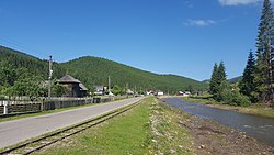
 The Moldovița passing through Argel | |
| Location | |
| Country | Romania |
| Counties | Suceava County |
| Physical characteristics | |
| Mouth | Moldova |
• location | Vama |
• coordinates | 47°34′11″N 25°42′18″E / 47.5696°N 25.7049°E |
| Length | 48 km (30 mi) |
| Basin size | 549 km2 (212 sq mi) |
| Basin features | |
| Progression | Moldova→ Siret→ Danube→ Black Sea |
The Moldovița (in its upper course also: Roșoșa) is a left tributary of the river Moldova in Romania. [1] [2] [3] It discharges into the Moldova in Vama. [4] It flows through the villages Argel, Rașca, Moldovița, Vatra Moldoviței, Frumosu, Strâmtura and Vama. Its length is 48 km (30 mi) and its basin size is 549 km2 (212 sq mi). [2]
The following rivers are tributaries to the river Moldovița: [2]
- Left: Dubu, Rașcova (Rașca), Săcrieș, Ciumârna, Lupoaia, Dragoșa, Frumosul
- Right: Argel, Lunguleț, Demăcușa, Vulcan, Pârâul Boului, Deia
- ^ "Planul național de management. Sinteza planurilor de management la nivel de bazine/spații hidrografice, anexa 7.1" (PDF, 5.1 MB). Administrația Națională Apele Române. 2010. p. 933.
- ^ a b c Atlasul cadastrului apelor din România. Partea 1 (in Romanian). Bucharest: Ministerul Mediului. 1992. pp. 377–378. OCLC 895459847. River code: XII.1.40.20
- ^ Ovidiu Gabor - "Economic Mechanism in Water Management" (PDF). Archived from the original (PDF) on 5 March 2009., map page 10
- ^ Moldovita (jud. Suceava), e-calauza.ro
- " Mołdawica". Geographical Dictionary of the Kingdom of Poland (in Polish). 6. Warszawa: Kasa im. Józefa Mianowskiego. 1885. p. 644.
| Moldovița | |
|---|---|
 The Moldovița passing through Argel | |
| Location | |
| Country | Romania |
| Counties | Suceava County |
| Physical characteristics | |
| Mouth | Moldova |
• location | Vama |
• coordinates | 47°34′11″N 25°42′18″E / 47.5696°N 25.7049°E |
| Length | 48 km (30 mi) |
| Basin size | 549 km2 (212 sq mi) |
| Basin features | |
| Progression | Moldova→ Siret→ Danube→ Black Sea |
The Moldovița (in its upper course also: Roșoșa) is a left tributary of the river Moldova in Romania. [1] [2] [3] It discharges into the Moldova in Vama. [4] It flows through the villages Argel, Rașca, Moldovița, Vatra Moldoviței, Frumosu, Strâmtura and Vama. Its length is 48 km (30 mi) and its basin size is 549 km2 (212 sq mi). [2]
The following rivers are tributaries to the river Moldovița: [2]
- Left: Dubu, Rașcova (Rașca), Săcrieș, Ciumârna, Lupoaia, Dragoșa, Frumosul
- Right: Argel, Lunguleț, Demăcușa, Vulcan, Pârâul Boului, Deia
- ^ "Planul național de management. Sinteza planurilor de management la nivel de bazine/spații hidrografice, anexa 7.1" (PDF, 5.1 MB). Administrația Națională Apele Române. 2010. p. 933.
- ^ a b c Atlasul cadastrului apelor din România. Partea 1 (in Romanian). Bucharest: Ministerul Mediului. 1992. pp. 377–378. OCLC 895459847. River code: XII.1.40.20
- ^ Ovidiu Gabor - "Economic Mechanism in Water Management" (PDF). Archived from the original (PDF) on 5 March 2009., map page 10
- ^ Moldovita (jud. Suceava), e-calauza.ro
- " Mołdawica". Geographical Dictionary of the Kingdom of Poland (in Polish). 6. Warszawa: Kasa im. Józefa Mianowskiego. 1885. p. 644.
