This article has multiple issues. Please help
improve it or discuss these issues on the
talk page. (
Learn how and when to remove these template messages)
|
Mokro Polje
| |
|---|---|
Village | |
 | |
|
| |
 Mokro Polje | |
| Coordinates: 44°05′09″N 16°01′50″E / 44.08583°N 16.03056°E | |
| Country | |
| County | Šibenik-Knin County |
| Municipality | Ervenik |
| Area | |
| • Total | 55.2 km2 (21.3 sq mi) |
| Elevation | 181 m (594 ft) |
| Population (2021)
[3] | |
| • Total | 163 |
| • Density | 3.0/km2 (7.6/sq mi) |
| Time zone | UTC+1 ( CET) |
| • Summer ( DST) | UTC+2 ( CEST) |
Mokro Polje ( Serbian Cyrillic: Мокро Поље) [1] is a village in Šibenik-Knin County, Croatia. It is one of the largest villages in the municipality of Ervenik. The river Zrmanja flows through Mokro Polje. The 2011 census listed 227 inhabitants. [4]
History
The Orthodox Church of St. Luka, built in 1537, is located within the village cadastral area. During the Croatian War, Mokro Polje was included in the Republic of Serbian Krajina (1991–95).
Demographics
According to the 2011 census, [4] the village of Mokro Polje has 227 inhabitants. This represents 28.27% of its pre- war population according to the 1991 census.
The 1991 census [5] recorded that 99.75% of the village population were ethnic Serbs (801/803) [6] while 0.25% were of other ethnic origin (2/803).
Sights and events
- Orthodox Church of St. Luka
- Monument to the fallen partisans and victims of fascism - built in 1952 and destroyed in November 1996 [8]
- Mokropoljski susreti - a sporting and cultural event taking place at the end of July [9] [10] [11]
Notable natives and residents
- Mira Bjedov (born 1955) - a former basketball player who competed for Yugoslavia in the 1980 Summer Olympics.
Gallery
-
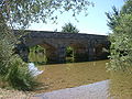 Bridge over the Zrmanja river
 -
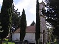 Serb Orthodox Church of St. Luka
 -
 The Keglevića Tower
 -
 Health centre and post office
 -
 Turn towards Mokro Polje (from Pađene)
 -
 Zrmanja river next to Bjedov
 -
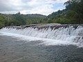 Zrmanja waterfalls


References
- ^ a b Government of Croatia (October 2013). "Peto izvješće Republike Hrvatske o primjeni Europske povelje o regionalnim ili manjinskim jezicima" (PDF) (in Croatian). Council of Europe. p. 36. Retrieved 30 November 2016.
- ^ Register of spatial units of the State Geodetic Administration of the Republic of Croatia. Wikidata Q119585703.
- ^ "Population by Age and Sex, by Settlements" (xlsx). Census of Population, Households and Dwellings in 2021. Zagreb: Croatian Bureau of Statistics. 2022.
- ^ a b c "Population by Age and Sex, by Settlements, 2011 Census: Mokro Polje". Census of Population, Households and Dwellings 2011. Zagreb: Croatian Bureau of Statistics. December 2012.
- ^ Izdanje Državnog zavoda za statistiku RH: Narodnosni sastav stanovništva RH od 1880-1991. godine.
- ^ "Prekinimo spiralu mržnje". portalnovosti.com (in Serbian). 4 August 2018. Retrieved 12 August 2018.
- ^ Naselja i stanovništvo Republike Hrvatske 1857-2001, www.dzs.hr
- ^ O spomeniku palim borcima [1] Archived 2009-09-11 at the Wayback Machine
- ^ "Mokropoljski susreti 2014". ervenik.hr (in Croatian). 23 July 2014. Retrieved 12 August 2018.
- ^ "Skakanje na mješinu, Mokropoljski susreti 2013". Goran B (in Croatian). 22 August 2013. Retrieved 12 August 2018.
- ^ "47. Mokropoljski susreti 28.07.2013". Goran B (in Croatian). 14 August 2013. Retrieved 12 August 2018.
44°04′41″N 16°02′46″E / 44.078°N 16.046°E
|
| This Šibenik-Knin County geography article is a stub. You can help Wikipedia by expanding it. |
This article has multiple issues. Please help
improve it or discuss these issues on the
talk page. (
Learn how and when to remove these template messages)
|
Mokro Polje
| |
|---|---|
Village | |
|
| |
|
| |
Mokro Polje | |
| Coordinates: 44°05′09″N 16°01′50″E / 44.08583°N 16.03056°E | |
| Country | |
| County | Šibenik-Knin County |
| Municipality | Ervenik |
| Area | |
| • Total | 55.2 km2 (21.3 sq mi) |
| Elevation | 181 m (594 ft) |
| Population (2021)
[3] | |
| • Total | 163 |
| • Density | 3.0/km2 (7.6/sq mi) |
| Time zone | UTC+1 ( CET) |
| • Summer ( DST) | UTC+2 ( CEST) |
Mokro Polje ( Serbian Cyrillic: Мокро Поље) [1] is a village in Šibenik-Knin County, Croatia. It is one of the largest villages in the municipality of Ervenik. The river Zrmanja flows through Mokro Polje. The 2011 census listed 227 inhabitants. [4]
History
The Orthodox Church of St. Luka, built in 1537, is located within the village cadastral area. During the Croatian War, Mokro Polje was included in the Republic of Serbian Krajina (1991–95).
Demographics
According to the 2011 census, [4] the village of Mokro Polje has 227 inhabitants. This represents 28.27% of its pre- war population according to the 1991 census.
The 1991 census [5] recorded that 99.75% of the village population were ethnic Serbs (801/803) [6] while 0.25% were of other ethnic origin (2/803).
Sights and events
- Orthodox Church of St. Luka
- Monument to the fallen partisans and victims of fascism - built in 1952 and destroyed in November 1996 [8]
- Mokropoljski susreti - a sporting and cultural event taking place at the end of July [9] [10] [11]
Notable natives and residents
- Mira Bjedov (born 1955) - a former basketball player who competed for Yugoslavia in the 1980 Summer Olympics.
Gallery
-
Bridge over the Zrmanja river
-
Serb Orthodox Church of St. Luka
-
The Keglevića Tower
-
Health centre and post office
-
Turn towards Mokro Polje (from Pađene)
-
Zrmanja river next to Bjedov
-
Zrmanja waterfalls
References
- ^ a b Government of Croatia (October 2013). "Peto izvješće Republike Hrvatske o primjeni Europske povelje o regionalnim ili manjinskim jezicima" (PDF) (in Croatian). Council of Europe. p. 36. Retrieved 30 November 2016.
- ^ Register of spatial units of the State Geodetic Administration of the Republic of Croatia. Wikidata Q119585703.
- ^ "Population by Age and Sex, by Settlements" (xlsx). Census of Population, Households and Dwellings in 2021. Zagreb: Croatian Bureau of Statistics. 2022.
- ^ a b c "Population by Age and Sex, by Settlements, 2011 Census: Mokro Polje". Census of Population, Households and Dwellings 2011. Zagreb: Croatian Bureau of Statistics. December 2012.
- ^ Izdanje Državnog zavoda za statistiku RH: Narodnosni sastav stanovništva RH od 1880-1991. godine.
- ^ "Prekinimo spiralu mržnje". portalnovosti.com (in Serbian). 4 August 2018. Retrieved 12 August 2018.
- ^ Naselja i stanovništvo Republike Hrvatske 1857-2001, www.dzs.hr
- ^ O spomeniku palim borcima [1] Archived 2009-09-11 at the Wayback Machine
- ^ "Mokropoljski susreti 2014". ervenik.hr (in Croatian). 23 July 2014. Retrieved 12 August 2018.
- ^ "Skakanje na mješinu, Mokropoljski susreti 2013". Goran B (in Croatian). 22 August 2013. Retrieved 12 August 2018.
- ^ "47. Mokropoljski susreti 28.07.2013". Goran B (in Croatian). 14 August 2013. Retrieved 12 August 2018.
44°04′41″N 16°02′46″E / 44.078°N 16.046°E
|
| This Šibenik-Knin County geography article is a stub. You can help Wikipedia by expanding it. |