Photos • Location

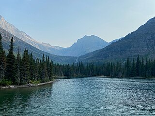
Mokowanis Lake and Pyramid Peak

| Mokowanis Lake | |
|---|---|
 Mokowanis Lake  Mokowanis Lake | |
| Location | Glacier National Park, Glacier County, Montana, US |
| Coordinates | 48°52′45″N 113°48′53″W / 48.87917°N 113.81472°W [1] |
| Type | Natural |
| Primary inflows | Pyramid Creek |
| Primary outflows | Pyramid Creek |
| Basin countries | United States |
| Max. length | .40 mi (0.64 km) |
| Max. width | .15 mi (0.24 km) |
| Surface elevation | 4,981 ft (1,518 m) |
Mokowanis Lake is in Glacier National Park in the U. S. state of Montana, .80 miles (1.29 km) north of Margaret Lake and just northeast of Pyramid Peak. Glenns Lake lies less than .50 miles (0.80 km) north of Mokowanis Lake. [2]

See also
Gallery
-
 Mokowanis lake viewed from atop Pyramid Falls
 -
 Mokowanis Lake with Pyramid Falls in the distance


References
- ^ "Mokowanis Lake". Geographic Names Information System. United States Geological Survey, United States Department of the Interior. Retrieved 2011-01-29.
- ^ "Mount Cleveland, MT" (Map (USGS Quad)). TopoQuest. Retrieved 2011-01-29.
|
| This Glacier County, Montana state location article is a stub. You can help Wikipedia by expanding it. |
| Mokowanis Lake | |
|---|---|
Mokowanis Lake Mokowanis Lake | |
| Location | Glacier National Park, Glacier County, Montana, US |
| Coordinates | 48°52′45″N 113°48′53″W / 48.87917°N 113.81472°W [1] |
| Type | Natural |
| Primary inflows | Pyramid Creek |
| Primary outflows | Pyramid Creek |
| Basin countries | United States |
| Max. length | .40 mi (0.64 km) |
| Max. width | .15 mi (0.24 km) |
| Surface elevation | 4,981 ft (1,518 m) |
Mokowanis Lake is in Glacier National Park in the U. S. state of Montana, .80 miles (1.29 km) north of Margaret Lake and just northeast of Pyramid Peak. Glenns Lake lies less than .50 miles (0.80 km) north of Mokowanis Lake. [2]
See also
Gallery
-
Mokowanis lake viewed from atop Pyramid Falls
-
Mokowanis Lake with Pyramid Falls in the distance
References
- ^ "Mokowanis Lake". Geographic Names Information System. United States Geological Survey, United States Department of the Interior. Retrieved 2011-01-29.
- ^ "Mount Cleveland, MT" (Map (USGS Quad)). TopoQuest. Retrieved 2011-01-29.
|
| This Glacier County, Montana state location article is a stub. You can help Wikipedia by expanding it. |