| Moher Tower | |
|---|---|
Irish: Túr an Mhothair | |
 Moher Tower | |
 | |
| Former names | Moher Uí Ruis or Moher Uí Ruidhin |
| General information | |
| Status | ruin |
| Type | signaling/watchtower |
| Location | Hag's Head, County Clare |
| Country | Ireland |
| Coordinates | 52°56′54″N 9°28′04″W / 52.948212°N 9.467861°W |
| Estimated completion | c.1808 [1] |
Moher Tower ( Irish: Túr an Mhothair; historically Moher Uí Ruis or Moher Uí Ruidhin) [2] is the stone ruin of an old Napoleonic-era watchtower which stands on Hag's Head, at the southern end of the Cliffs of Moher, in County Clare, Ireland.
The current tower (which was built c.1808) stands close to the site of a much earlier promontory fort, known as Mothar or Moher. [3] This earlier fortification stood until at least 1780 and is mentioned in an account from John Lloyd's a Short Tour Of Clare (1780). [4] The earlier fortification was demolished in 1808 to provide material for a new lookout/signaling tower. [2] This was built nearby during the Napoleonic Wars (1803–1815), at a time when similar towers were built along Atlantic coasts to counter fears of invasion during Napoleon's reign in Europe. [2] [5]
The building is a single, nearly square, tower with two rectilinear bartizans protruding from the top of its eastern wall, and one from the western wall. [1] Facing the Atlantic Ocean, the structure appears to have incorporated a fireplace on at least 2 floors, and a dry stone roof which has since mostly caved in.[ citation needed]
In summer the tower ruin is occupied by the many choughs and similar birds native to the area. The tower is sometimes used as a refuge by visitors to the Cliffs of Moher who become stranded on the southern cliff path during storms that blow in from the Atlantic.[ citation needed]
-
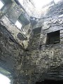 Inside Moher Tower
 -
 Moher Tower on Hag's Head


- ^
a
b Mary Tunney (2016). Sites and Monuments Record. National Monuments Service.
CL014-010002- [..] Signal tower [..] Situated close to Hag's Head and within a promontory fort (CL014-010001-). The ruins of a Napoleonic signal tower built in 1808. A two-storey square tower defended by two rectangular bartizans protruding from the top of the E wall and one from the W wall
- ^ a b c Thomas Johnson Westropp (1905). "Archaeology of the Burren: Prehistoric Forts and Dolmens in North Clare (Part IV: Moher Ui Ruis; Lehinch; Dooneeve; Cahers)". Journal of the Royal Society of Antiquaries of Ireland. xxxv.
-
^ Doolin Web Solutions (2010).
"About the Cliffs of Moher". cliffs-moher.com. Archived from
the original on 2 March 2018.
The Napoleonic signal tower at Hags Head was built [..] close to the site of a long gone 1st century BC ruined fort "Mothar" from which the Cliffs get their name
- ^ John Lloyd (1780). "Burren, Mohar, Liscanor Bay". Lloyd's Tour of Clare. John Busteed & George Trinder – via Clare Library.
-
^ Eamonn Kelly (2009). "How The Cliffs Were Named". The Cliffs of Moher. Matthew Kelly.
ISBN
0-9561746-0-4.
The present tower built near the site of the old Moher Ui Ruidhin was built by the British as a lookout tower during the Napoleonic Wars
| Moher Tower | |
|---|---|
Irish: Túr an Mhothair | |
|
Moher Tower | |
| |
| Former names | Moher Uí Ruis or Moher Uí Ruidhin |
| General information | |
| Status | ruin |
| Type | signaling/watchtower |
| Location | Hag's Head, County Clare |
| Country | Ireland |
| Coordinates | 52°56′54″N 9°28′04″W / 52.948212°N 9.467861°W |
| Estimated completion | c.1808 [1] |
Moher Tower ( Irish: Túr an Mhothair; historically Moher Uí Ruis or Moher Uí Ruidhin) [2] is the stone ruin of an old Napoleonic-era watchtower which stands on Hag's Head, at the southern end of the Cliffs of Moher, in County Clare, Ireland.
The current tower (which was built c.1808) stands close to the site of a much earlier promontory fort, known as Mothar or Moher. [3] This earlier fortification stood until at least 1780 and is mentioned in an account from John Lloyd's a Short Tour Of Clare (1780). [4] The earlier fortification was demolished in 1808 to provide material for a new lookout/signaling tower. [2] This was built nearby during the Napoleonic Wars (1803–1815), at a time when similar towers were built along Atlantic coasts to counter fears of invasion during Napoleon's reign in Europe. [2] [5]
The building is a single, nearly square, tower with two rectilinear bartizans protruding from the top of its eastern wall, and one from the western wall. [1] Facing the Atlantic Ocean, the structure appears to have incorporated a fireplace on at least 2 floors, and a dry stone roof which has since mostly caved in.[ citation needed]
In summer the tower ruin is occupied by the many choughs and similar birds native to the area. The tower is sometimes used as a refuge by visitors to the Cliffs of Moher who become stranded on the southern cliff path during storms that blow in from the Atlantic.[ citation needed]
-
Inside Moher Tower
-
Moher Tower on Hag's Head
- ^
a
b Mary Tunney (2016). Sites and Monuments Record. National Monuments Service.
CL014-010002- [..] Signal tower [..] Situated close to Hag's Head and within a promontory fort (CL014-010001-). The ruins of a Napoleonic signal tower built in 1808. A two-storey square tower defended by two rectangular bartizans protruding from the top of the E wall and one from the W wall
- ^ a b c Thomas Johnson Westropp (1905). "Archaeology of the Burren: Prehistoric Forts and Dolmens in North Clare (Part IV: Moher Ui Ruis; Lehinch; Dooneeve; Cahers)". Journal of the Royal Society of Antiquaries of Ireland. xxxv.
-
^ Doolin Web Solutions (2010).
"About the Cliffs of Moher". cliffs-moher.com. Archived from
the original on 2 March 2018.
The Napoleonic signal tower at Hags Head was built [..] close to the site of a long gone 1st century BC ruined fort "Mothar" from which the Cliffs get their name
- ^ John Lloyd (1780). "Burren, Mohar, Liscanor Bay". Lloyd's Tour of Clare. John Busteed & George Trinder – via Clare Library.
-
^ Eamonn Kelly (2009). "How The Cliffs Were Named". The Cliffs of Moher. Matthew Kelly.
ISBN
0-9561746-0-4.
The present tower built near the site of the old Moher Ui Ruidhin was built by the British as a lookout tower during the Napoleonic Wars