Mlýnské Struhadlo | |
|---|---|
 Chapel in the centre of Mlýnské Struhadlo | |
 Mlýnské Struhadlo Location in the Czech Republic | |
| Coordinates: 49°25′54″N 13°28′12″E / 49.43167°N 13.47000°E | |
| Country | |
| Region | Plzeň |
| District | Klatovy |
| First mentioned | 1437 |
| Area | |
| • Total | 4.04 km2 (1.56 sq mi) |
| Elevation | 498 m (1,634 ft) |
| Population (2023-01-01)
[1] | |
| • Total | 50 |
| • Density | 12/km2 (32/sq mi) |
| Time zone | UTC+1 ( CET) |
| • Summer ( DST) | UTC+2 ( CEST) |
| Postal code | 339 01 |
| Website |
www |
Mlýnské Struhadlo is a municipality and village in Klatovy District in the Plzeň Region of the Czech Republic. It has about 50 inhabitants.
Mlýnské Struhadlo lies approximately 15 kilometres (9 mi) east of Klatovy, 36 km (22 mi) south of Plzeň, and 100 km (62 mi) south-west of Prague.
Demographics
| Year | Pop. | ±% |
|---|---|---|
| 1869 | 228 | — |
| 1880 | 245 | +7.5% |
| 1890 | 253 | +3.3% |
| 1900 | 242 | −4.3% |
| 1910 | 284 | +17.4% |
| 1921 | 280 | −1.4% |
| 1930 | 261 | −6.8% |
| 1950 | 192 | −26.4% |
| 1961 | 179 | −6.8% |
| 1970 | 125 | −30.2% |
| 1980 | 95 | −24.0% |
| 1991 | 69 | −27.4% |
| 2001 | 54 | −21.7% |
| 2011 | 52 | −3.7% |
| 2021 | 56 | +7.7% |
| Source: Censuses [2] [3] | ||
Gallery
-
 Municipal office
 -
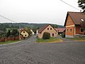
 Entrance to the village
 -
 General view
.jpg)


References
- ^ "Population of Municipalities – 1 January 2023". Czech Statistical Office. 2023-05-23.
- ^ "Historický lexikon obcí České republiky 1869–2011 – Okres Klatovy" (in Czech). Czech Statistical Office. 2015-12-21. pp. 17–18.
- ^ "Population Census 2021: Population by sex". Public Database. Czech Statistical Office. 2021-03-27.
External links
| Authority control databases: National |
|---|
|
| This Plzeň Region location article is a stub. You can help Wikipedia by expanding it. |
Mlýnské Struhadlo | |
|---|---|
|
Chapel in the centre of Mlýnské Struhadlo | |
Mlýnské Struhadlo Location in the Czech Republic | |
| Coordinates: 49°25′54″N 13°28′12″E / 49.43167°N 13.47000°E | |
| Country | |
| Region | Plzeň |
| District | Klatovy |
| First mentioned | 1437 |
| Area | |
| • Total | 4.04 km2 (1.56 sq mi) |
| Elevation | 498 m (1,634 ft) |
| Population (2023-01-01)
[1] | |
| • Total | 50 |
| • Density | 12/km2 (32/sq mi) |
| Time zone | UTC+1 ( CET) |
| • Summer ( DST) | UTC+2 ( CEST) |
| Postal code | 339 01 |
| Website |
www |
Mlýnské Struhadlo is a municipality and village in Klatovy District in the Plzeň Region of the Czech Republic. It has about 50 inhabitants.
Mlýnské Struhadlo lies approximately 15 kilometres (9 mi) east of Klatovy, 36 km (22 mi) south of Plzeň, and 100 km (62 mi) south-west of Prague.
Demographics
| Year | Pop. | ±% |
|---|---|---|
| 1869 | 228 | — |
| 1880 | 245 | +7.5% |
| 1890 | 253 | +3.3% |
| 1900 | 242 | −4.3% |
| 1910 | 284 | +17.4% |
| 1921 | 280 | −1.4% |
| 1930 | 261 | −6.8% |
| 1950 | 192 | −26.4% |
| 1961 | 179 | −6.8% |
| 1970 | 125 | −30.2% |
| 1980 | 95 | −24.0% |
| 1991 | 69 | −27.4% |
| 2001 | 54 | −21.7% |
| 2011 | 52 | −3.7% |
| 2021 | 56 | +7.7% |
| Source: Censuses [2] [3] | ||
Gallery
-
Municipal office
-
Entrance to the village
-
General view
References
- ^ "Population of Municipalities – 1 January 2023". Czech Statistical Office. 2023-05-23.
- ^ "Historický lexikon obcí České republiky 1869–2011 – Okres Klatovy" (in Czech). Czech Statistical Office. 2015-12-21. pp. 17–18.
- ^ "Population Census 2021: Population by sex". Public Database. Czech Statistical Office. 2021-03-27.
External links
| Authority control databases: National |
|---|
|
| This Plzeň Region location article is a stub. You can help Wikipedia by expanding it. |