Photos • Location
Mitterlabill | |
|---|---|
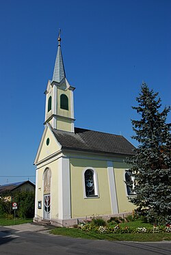
 Chapel in Mitterlabill | |
| Coordinates: 46°53′00″N 15°38′00″E / 46.88333°N 15.63333°E | |
| Country | Austria |
| State | Styria |
| District | Leibnitz |
| Government | |
| • Mayor | Adolf Totter ( ÖVP) |
| Area | |
| • Total | 7.88 km2 (3.04 sq mi) |
| Elevation | 309 m (1,014 ft) |
| Population (1 January 2016)
[1] | |
| • Total | 414 |
| • Density | 53/km2 (140/sq mi) |
| Time zone | UTC+1 ( CET) |
| • Summer ( DST) | UTC+2 ( CEST) |
| Postal code | 8413 |
| Area code | +43 3184 |
| Vehicle registration | FB |
| Website |
www.mitterlabill. steiermark.at |
Mitterlabill is a former municipality in the district of Südoststeiermark in the Austrian state of Styria. Since the 2015 Styria municipal structural reform, it is part of the municipality Schwarzautal, in the Leibnitz District. [2]
Population
| Year | Pop. | ±% |
|---|---|---|
| 1869 | 514 | — |
| 1880 | 534 | +3.9% |
| 1890 | 511 | −4.3% |
| 1900 | 531 | +3.9% |
| 1910 | 489 | −7.9% |
| 1923 | 516 | +5.5% |
| 1934 | 474 | −8.1% |
| 1939 | 461 | −2.7% |
| 1951 | 449 | −2.6% |
| 1961 | 443 | −1.3% |
| 1971 | 443 | +0.0% |
| 1981 | 464 | +4.7% |
| 1991 | 456 | −1.7% |
| 2001 | 447 | −2.0% |
| 2013 | 399 | −10.7% |
References
Mitterlabill | |
|---|---|
 Chapel in Mitterlabill | |
| Coordinates: 46°53′00″N 15°38′00″E / 46.88333°N 15.63333°E | |
| Country | Austria |
| State | Styria |
| District | Leibnitz |
| Government | |
| • Mayor | Adolf Totter ( ÖVP) |
| Area | |
| • Total | 7.88 km2 (3.04 sq mi) |
| Elevation | 309 m (1,014 ft) |
| Population (1 January 2016)
[1] | |
| • Total | 414 |
| • Density | 53/km2 (140/sq mi) |
| Time zone | UTC+1 ( CET) |
| • Summer ( DST) | UTC+2 ( CEST) |
| Postal code | 8413 |
| Area code | +43 3184 |
| Vehicle registration | FB |
| Website |
www.mitterlabill. steiermark.at |
Mitterlabill is a former municipality in the district of Südoststeiermark in the Austrian state of Styria. Since the 2015 Styria municipal structural reform, it is part of the municipality Schwarzautal, in the Leibnitz District. [2]
Population
| Year | Pop. | ±% |
|---|---|---|
| 1869 | 514 | — |
| 1880 | 534 | +3.9% |
| 1890 | 511 | −4.3% |
| 1900 | 531 | +3.9% |
| 1910 | 489 | −7.9% |
| 1923 | 516 | +5.5% |
| 1934 | 474 | −8.1% |
| 1939 | 461 | −2.7% |
| 1951 | 449 | −2.6% |
| 1961 | 443 | −1.3% |
| 1971 | 443 | +0.0% |
| 1981 | 464 | +4.7% |
| 1991 | 456 | −1.7% |
| 2001 | 447 | −2.0% |
| 2013 | 399 | −10.7% |
References
