Photos • Location
Município de Miranda | |
|---|---|
municipality | |
 Location in
Brazil | |
| Country |
|
| Region | Center-West |
| State | Mato Grosso do Sul |
| Founded | July 16, 1784 |
| Government | |
| • Mayor | Elisabeth de Paula Almeida |
| Area | |
| • Total | 5,478.63 km2 (2,115.31 sq mi) |
| Elevation | 125 m (410 ft) |
| Population (2020
[1]) | |
| • Total | 28,220 |
| • Density | 4.2/km2 (11/sq mi) |
| Time zone | UTC−4 ( AMT) |
| HDI (2000) | 0.724 – medium |
| Website | [1] |
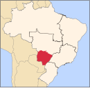
Miranda is a municipality located in the Brazilian state of Mato Grosso do Sul, Brazil, named for its location on the river by the same name. Its population was 28,220 in 2020 and its area is 5,479 km2.
References
20°14′27″S 56°22′40″W / 20.24083°S 56.37778°W
External links
Município de Miranda | |
|---|---|
municipality | |
 Location in
Brazil | |
| Country |
|
| Region | Center-West |
| State | Mato Grosso do Sul |
| Founded | July 16, 1784 |
| Government | |
| • Mayor | Elisabeth de Paula Almeida |
| Area | |
| • Total | 5,478.63 km2 (2,115.31 sq mi) |
| Elevation | 125 m (410 ft) |
| Population (2020
[1]) | |
| • Total | 28,220 |
| • Density | 4.2/km2 (11/sq mi) |
| Time zone | UTC−4 ( AMT) |
| HDI (2000) | 0.724 – medium |
| Website | [1] |
Miranda is a municipality located in the Brazilian state of Mato Grosso do Sul, Brazil, named for its location on the river by the same name. Its population was 28,220 in 2020 and its area is 5,479 km2.
References
20°14′27″S 56°22′40″W / 20.24083°S 56.37778°W


